| Mesoscale Discussion 852 | |
| < Previous MD | |

|
|
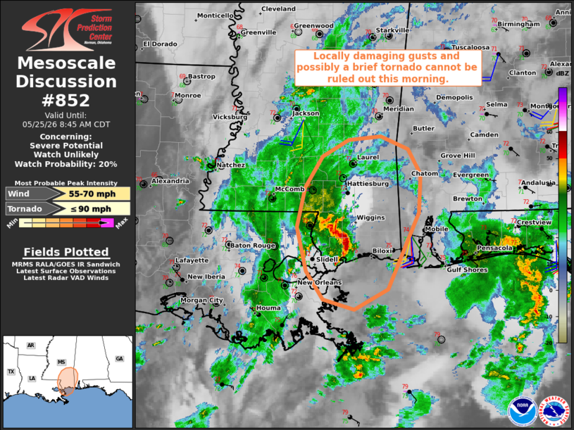
   Mesoscale Discussion 0852
   NWS Storm Prediction Center Norman OK
   0642 AM CDT Mon May 25 2026

   Areas affected...Parts of southern Mississippi and southeast
   Louisiana...and southwest Alabama

   Concerning...Severe potential...Watch unlikely

   Valid 251142Z - 251345Z

   Probability of Watch Issuance...20 percent

   SUMMARY...Locally damaging gusts and possibly a brief tornado cannot
   be ruled out this morning.

   DISCUSSION...Preceding a midlevel trough/low (evident in water-vapor
   imagery) over eastern TX, the latest radar data indicates an MCV
   moving onshore into southern MS. The MOB VWP is sampling
   deep-southerly flow and a small clockwise-curved low-level
   hodograph. Given a moist boundary layer (lower 70s dewpoints) and
   the modestly sheared environment, a couple loosely organized
   clusters with embedded rotation will be possible. This should
   generally be focused along/ahead of the northward-moving MCV over
   the next few hours. Locally damaging gusts and possibly a brief
   tornado cannot be ruled out with any stronger storms that evolve.

   ..Weinman/Smith.. 05/25/2026

   ...Please see www.spc.noaa.gov for graphic product...

   ATTN...WFO...MOB...JAN...LIX...

   LAT...LON   30178991 30799006 31338993 31768966 32008924 32048871
               31868828 31518807 30988811 29928860 29648914 29788964
               30178991

   MOST PROBABLE PEAK TORNADO INTENSITY...UP TO 90 MPH
   MOST PROBABLE PEAK WIND GUST...55-70 MPH
|
|
|
Top/All Mesoscale Discussions/Forecast Products/Home |
|
Source link