| Mesoscale Discussion 851 | |
| < Previous MD | |

|
|
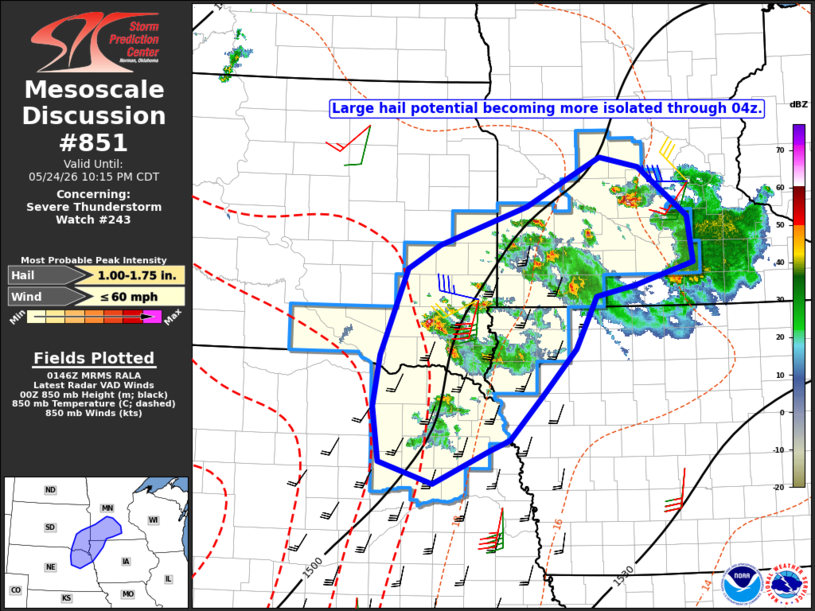
Mesoscale Discussion 0851 NWS Storm Prediction Center Norman OK 0848 PM CDT Sun May 24 2026 Areas affected...southwest Minnesota...southeast South Dakota...far northwest Iowa...and northeast Nebraska Concerning...Severe Thunderstorm Watch 243... Valid 250148Z - 250315Z The severe weather threat for Severe Thunderstorm Watch 243 continues. SUMMARY...Large-hail potential is expected to become more isolated through 04z. DISCUSSION...Recent radar and satellite trends indicate warming cloud tops and lowering reflectivity cores, which coincides with the gradual cooling and stabilization of the boundary layer. However, plan-view VWP data and short-term model forecasts indicate the strengthening of a nocturnal low-level jet from south-central NE into southeast SD. Enhanced convergence and moist flux within the terminus of that feature may support the continuation of isolated, strong to severe storms in far southeast SD and northwest IA for the next hour or two. Elsewhere, expect a gradual decrease in storm coverage and intensity through 04z as convective inhibition continues to increase. ..Mead.. 05/25/2026 ...Please see www.spc.noaa.gov for graphic product... ATTN...WFO...MPX...FSD...OAX... LAT...LON 41809818 42419827 42979817 43909778 44179729 44589600 44879541 45119490 45009431 44479358 43969350 43739437 43609496 43039526 42579571 42049625 41929655 41579738 41809818 MOST PROBABLE PEAK WIND GUST...UP TO 60 MPH MOST PROBABLE PEAK HAIL SIZE...1.00-1.75 IN |
|
|
Top/All Mesoscale Discussions/Forecast Products/Home |
|
Source link