| Mesoscale Discussion 85 | |
| < Previous MD | |

|
|
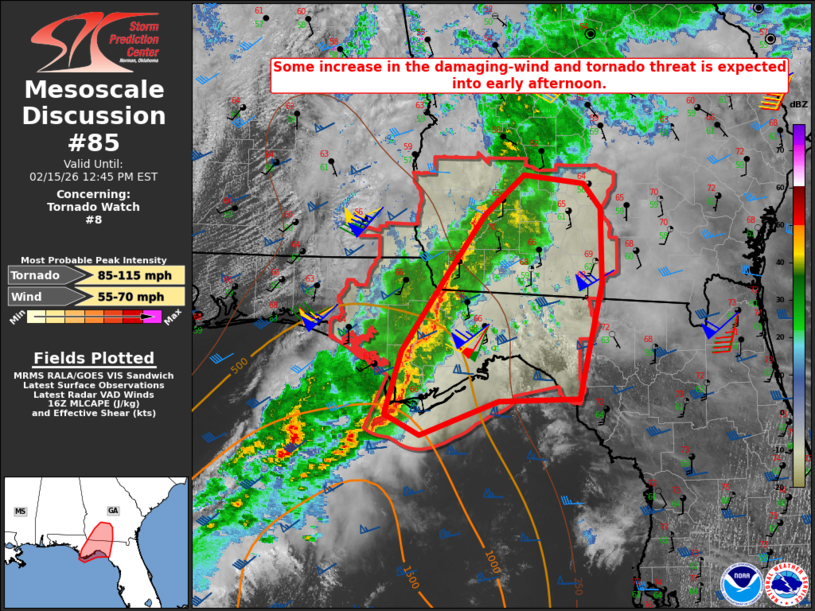
Mesoscale Discussion 0085 NWS Storm Prediction Center Norman OK 1012 AM CST Sun Feb 15 2026 Areas affected...Parts of the FL Panhandle/Big Bend into southwest GA Concerning...Tornado Watch 8... Valid 151612Z - 151745Z The severe weather threat for Tornado Watch 8 continues. SUMMARY...Some increase in the damaging-wind and localized tornado threat is expected into early afternoon. DISCUSSION...A long-lived QLCS has intensified somewhat this morning over the FL Panhandle and adjacent coastal waters, with deeper updrafts and an increase in lightning activity noted over the last 2-3 hours. This QLCS will continue to move eastward into early afternoon, in advance of a deep-layer cyclone moving across central/northern MS/AL. While the primary cyclone is forecast to gradually weaken through the day, low-level and deep-layer shear are expected to remain strong across the warm sector into this afternoon. Inland buoyancy is currently weak (with MLCAPE of near/below 500 J/kg), but some additional destabilization is expected with time from the FL Panhandle/Big Bend into southwest GA, due to filtered heating and continued low-level moisture transport. The strong flow and effective SRH of 200-400 m2/s2 will continue to support potential for persistent bowing segments and embedded mesovortices, with an attendant threat of strong/damaging gusts and a couple tornadoes. ..Dean.. 02/15/2026 ...Please see www.spc.noaa.gov for graphic product... ATTN...WFO...JAX...TAE... LAT...LON 30158523 30888473 31388437 31758394 31688332 31448313 30768313 29718336 29688421 29378505 29578541 30158523 MOST PROBABLE PEAK TORNADO INTENSITY...85-115 MPH MOST PROBABLE PEAK WIND GUST...55-70 MPH |
|
|
Top/All Mesoscale Discussions/Forecast Products/Home |
|
Source link