| Mesoscale Discussion 849 | |
| < Previous MD | |
|
|
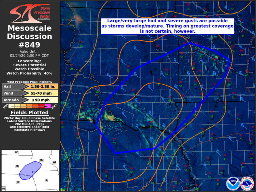
   Mesoscale Discussion 0849
   NWS Storm Prediction Center Norman OK
   0334 PM CDT Sun May 24 2026

   Areas affected...Northeast Nebraska into southwest Minnesota

   Concerning...Severe potential...Watch possible

   Valid 242034Z - 242200Z

   Probability of Watch Issuance...40 percent

   SUMMARY...Large to very large hail and severe winds will be possible
   when storms develop/mature this afternoon. Timing remains uncertain,
   but a watch is possible by late afternoon.

   DISCUSSION...Deeper cumulus have developed near the SD/NE border.
   Additional, but more shallow, development has also been noted from
   near Sioux Falls into southwest Minnesota. How soon any of this
   activity can develop into sustained thunderstorms is not clear given
   the subtly rising mid-level heights this afternoon. Given the strong
   surface heating, it is possible that a storm or two develops within
   the next 1-2 hours. However, it is more probable that more robust
   convection will initiate as lift from a shortwave trough now in
   eastern Montana arrives closer to 00Z. 30-35 kt of effective shear
   and -16 to -17 C at 500 mb (per 18Z ABR/OAX soundings) suggest
   large/very-large hail and severe winds would be possible with
   supercells. Timing of watch issuance remains uncertain. It is more
   probable by late afternoon, but could be sooner if convective trends
   warrant.

   ..Wendt.. 05/24/2026

   ...Please see www.spc.noaa.gov for graphic product...

   ATTN...WFO...MPX...FSD...OAX...ABR...LBF...

   LAT...LON   44389801 45049604 44849515 44599462 44329469 44109485
               42849647 42709666 42309732 42159872 42879942 43519908
               44389801

   MOST PROBABLE PEAK TORNADO INTENSITY...UP TO 90 MPH
   MOST PROBABLE PEAK WIND GUST...55-70 MPH
   MOST PROBABLE PEAK HAIL SIZE...1.50-2.50 IN
|
|
|
Top/All Mesoscale Discussions/Forecast Products/Home |
|
Source link