| Mesoscale Discussion 846 | |
| < Previous MD | |
|
|
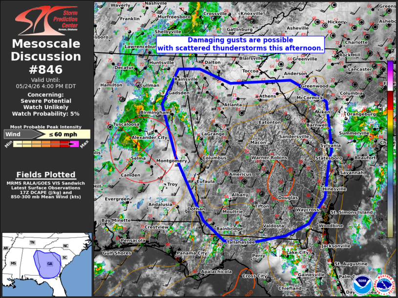
   Mesoscale Discussion 0846
   NWS Storm Prediction Center Norman OK
   1255 PM CDT Sun May 24 2026

   Areas affected...Much of Georgia...eastern Alabama... into far
   western South Carolina

   Concerning...Severe potential...Watch unlikely

   Valid 241755Z - 242000Z

   Probability of Watch Issuance...5 percent

   SUMMARY...Scattered thunderstorms may pose a risk for occasional
   damaging gusts this afternoon. Storm organization will be limited
   and a WW is unlikely.

   DISCUSSION...As of 1745 UTC, visible and radar imagery showed
   thunderstorms increasing in coverage over eastern AL, FL and much of
   GA. Ample heating is occurring within a very moist air mass (70s F
   dewpoints) supporting moderate instability. While low and mid-level
   flow are quite weak, locally stronger convergence is occurring near
   a broad MCV along the AL/GA border. This will continue to serve as a
   focus for convective development this afternoon, with additional
   storms likely to develop within the warm sector as convective
   temperatures are breached. One or more clusters of stronger storms
   appears plausible, with convection gradually spreading
   east/northeastward into SC this afternoon/evening.

   Given the very weak vertical shear, pulse multicellular storms are
   the expected mode. Heavy water loading (PWATS near or exceeding 2
   inches) will favor damaging gust potential with the stronger
   downdrafts. But, the lack of broader upper air support and very weak
   shear suggests the threat will be isolated and dependent on
   favorable outflow interactions and storm-scale clustering. With the
   severe potential likely to be sporadic, a WW is very unlikely.

   ..Lyons/Guyer.. 05/24/2026

   ...Please see www.spc.noaa.gov for graphic product...

   ATTN...WFO...CHS...CAE...GSP...JAX...FFC...TAE...BMX...HUN...

   LAT...LON   30518351 30548433 31028490 32578573 33828614 34678570
               34698508 34358418 34418243 33888139 32748127 32338138
               31588149 30958197 30668262 30518351

   MOST PROBABLE PEAK WIND GUST...UP TO 60 MPH
|
|
|
Top/All Mesoscale Discussions/Forecast Products/Home |
|
Source link