|
|
| Mesoscale Discussion 845 | |
| < Previous MD | |

|
|
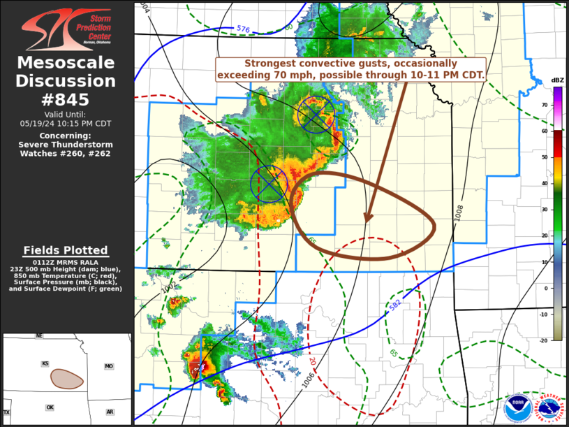
Mesoscale Discussion 0845 NWS Storm Prediction Center Norman OK 0815 PM CDT Sun May 19 2024 Areas affected...southeastern Kansas Concerning...Severe Thunderstorm Watch 260...262... Valid 200115Z - 200315Z The severe weather threat for Severe Thunderstorm Watch 260, 262 continues. SUMMARY...Stronger surface gusts, perhaps occasionally exceeding 70 mph, may be maintained with an evolving cluster of storms northeast and east of Wichita toward the Joplin MO/Bartlesville OK vicinities through 10-11 PM CDT. DISCUSSION...Trailing one still well-defined MCV now migrating eastward along the I-70 corridor near Manhattan, a second MCV is becoming better-defined along intersecting outflow boundaries to the north of Wichita. Associated with this evolution, measured gusts to 75 kt were recorded in Hutchinson at 0039Z. Although inflow into the convective system may become less unstable due to somewhat drier low-level air across much of eastern Kansas/Oklahoma, strong to severe gusts may continue at least another couple of hours to the southwest/south of the evolving southern MCV. ..Kerr.. 05/20/2024 ...Please see www.spc.noaa.gov for graphic product... ATTN...WFO...SGF...TOP...ICT... LAT...LON 38269688 38149597 37609492 37189563 37319681 37879723 38269688 |
|
|
Top/All Mesoscale Discussions/Forecast Products/Home |
|


