| Mesoscale Discussion 842 | |
| < Previous MD | |
|
|
Mesoscale Discussion 0842
NWS Storm Prediction Center Norman OK
0339 PM CDT Sat May 23 2026
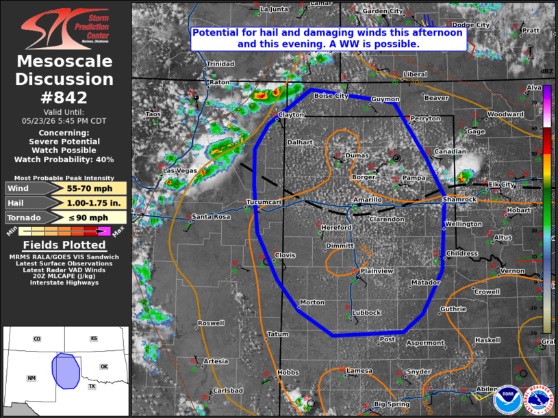
Areas affected...portions of northeastern new Mexico into the
Texas/Oklahoma Panhandles.
Concerning...Severe potential...Watch possible
Valid 232039Z - 232245Z
Probability of Watch Issuance...40 percent
SUMMARY...Isolated to widely scattered thunderstorms are expected to
pose a risk for hail and some damaging winds into this evening. A WW
is possible.
DISCUSSION...Across portions of the southern High Plains, afternoon
satellite and radar imagery showed high-based convection
strengthening across the southern Raton mesa in northeastern NM and
southeastern CO. South of a broad upper trough and modestly enhanced
westerly flow aloft, weak upslope flow has resulted in modest
destabilization of the air mass so far this afternoon. Continued
warming will support around 1000 J/kg of MLCAPE amid steep low and
mid-level lapse rates (18z AMA sounding). 20-30 kt of deep-layer
flow on area VADs is supportive of a mixed mode of multicellular and
transient supercell structures.
Ongoing storms over NM/CO should continue east/southeastward with
gradual intensification as they encounter more buoyancy. Additional,
more isolated, storm development is possible along a subtle sfc
confluence axis across the central TX Panhandle. CAM guidance and
observational trends shows these storms intensifying, with an
associated increase in the severe risk through the remainder of the
afternoon and into the early evening.
Isolated large hail is possible initially, especially with any
longer-lived supercells. Some potential for severe wind gusts is
also possible given the steep low-level lapse rates. This threat
could increase further as a gradual clustering is expected during
the evening hours across southern portions of the TX Panhandle where
buoyancy is greater. With severe potential expected to increase, a
WW is possible over the next couple of hours.
..Lyons/Guyer.. 05/23/2026
...Please see www.spc.noaa.gov for graphic product...
ATTN...WFO...LUB...AMA...ABQ...
LAT...LON 33660275 34120314 34790350 35490357 36000356 36380333
36880256 36700107 35890050 35330019 34250025 33620060
33360094 33300216 33660275
MOST PROBABLE PEAK TORNADO INTENSITY...UP TO 90 MPH
MOST PROBABLE PEAK WIND GUST...55-70 MPH
MOST PROBABLE PEAK HAIL SIZE...1.00-1.75 IN
|
|
|
Top/All Mesoscale Discussions/Forecast Products/Home |
|
Source link