| Mesoscale Discussion 841 | |
| < Previous MD | |

|
|
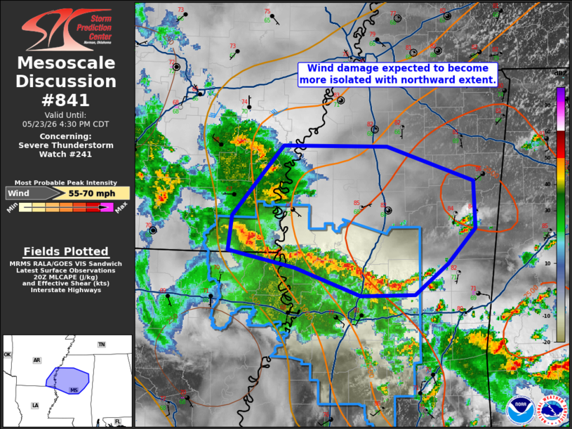
Mesoscale Discussion 0841 NWS Storm Prediction Center Norman OK 0303 PM CDT Sat May 23 2026 Areas affected...Central/northern Mississippi...southeast Arkansas Concerning...Severe Thunderstorm Watch 241... Valid 232003Z - 232130Z The severe weather threat for Severe Thunderstorm Watch 241 continues. SUMMARY...Though becoming more isolated with time, damaging winds will remain a concern into parts of northern Mississippi this afternoon. Additional watches are not expected. DISCUSSION...Trends in MRMS CAPPI data have shown a gradual downward trend in the intensity of the convective line moving north through Mississippi. This trend is expected to continue as greater effective shear values lift northward with time. That said, upper 60s F dewpoints in parts of northern Mississippi are supporting 2000 J/kg MLCAPE and low-level lapse rates are at least modestly steep. Wind damage will remain possible with the convective line as it lifts north, but this potential should become more isolated with time. ..Wendt.. 05/23/2026 ...Please see www.spc.noaa.gov for graphic product... ATTN...WFO...MEG...JAN...LZK... LAT...LON 33798860 33268858 32888895 32538937 32529008 32839094 33029181 33409177 34189110 34168973 33798860 MOST PROBABLE PEAK WIND GUST...55-70 MPH |
|
|
Top/All Mesoscale Discussions/Forecast Products/Home |
|
Source link