| Mesoscale Discussion 840 | |
| < Previous MD Next MD > | |

|
|
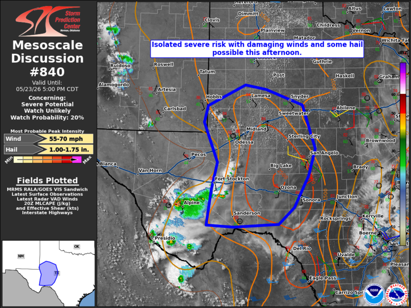
   Mesoscale Discussion 0840
   NWS Storm Prediction Center Norman OK
   0302 PM CDT Sat May 23 2026

   Areas affected...portions of West Texas

   Concerning...Severe potential...Watch unlikely

   Valid 232002Z - 232200Z

   Probability of Watch Issuance...20 percent

   SUMMARY...Thunderstorms will increase in coverage this afternoon.
   One or more clusters with a risk for hail and damaging gusts is
   expected. The need for a WW is unclear.

   DISCUSSION...As of 20 UTC, visible and radar imagery showed
   convection increasing in coverage from the Davis Mountains into
   parts of southwestern and West TX. Strong heating and weak ascent
   from a subtle subtropical shortwave trough  should remove lingering
   inhibition over the next couple of hours. Ongoing high-based
   convection and its associated outflow should continue and may
   strengthen as additional storms develop over the southern High
   Plains and Edwards Plateau within the destabilizing air mass.

   Convective coverage should continue to increase this afternoon with
   a few stronger multicells and clusters becoming established. Steep
   mid-level lapse rates above 8.5 C/km (12z DRT sounding) will support
   strong multi cell updrafts with isolated hail potential. Surface
   winds and flow aloft are quite light suggesting storm organization
   will be episodic. Deep-layer shear is generally weak (EBWD <25 kt),
   but the degree of buoyancy (forecast MLCAPE 2000-2500 J/kg) and
   steep lapse rates could favor a risk for damaging winds, especially
   if substantial clustering of storms can occur.

   Given the expected increase in convective coverage, some severe risk
   is evident this afternoon and continuing into the evening hours. CAM
   guidance shows initial scattered storms gradually coalescing into a
   few stronger clusters and spreading eastward this evening. While
   some severe risk is possible, the lack of broader storm organization
   suggests a watch is possible but not overly likely in the short
   term. Convective trends will be monitored should the need for a
   watch become apparent.

   ..Lyons/Guyer.. 05/23/2026

   ...Please see www.spc.noaa.gov for graphic product...

   ATTN...WFO...EWX...SJT...LUB...MAF...

   LAT...LON   30730294 31340278 32220313 32590303 33040207 32950152
               32600058 31630026 31030044 30330082 29970121 29900237
               29950305 30730294

   MOST PROBABLE PEAK WIND GUST...55-70 MPH
   MOST PROBABLE PEAK HAIL SIZE...1.00-1.75 IN
|
|
|
Top/All Mesoscale Discussions/Forecast Products/Home |
|
Source link