| Mesoscale Discussion 84 | |
| < Previous MD | |

|
|
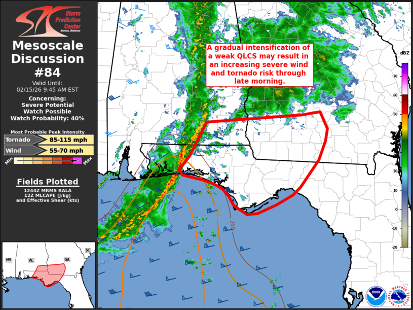
   Mesoscale Discussion 0084
   NWS Storm Prediction Center Norman OK
   0645 AM CST Sun Feb 15 2026

   Areas affected...Far southeast Alabama into the Florida Panhandle
   and southwest Georgia

   Concerning...Severe potential...Watch possible

   Valid 151245Z - 151445Z

   Probability of Watch Issuance...40 percent

   SUMMARY...A gradual intensification of a weak QLCS is anticipated
   through the morning hours. An uptick in severe wind and tornado
   potential is anticipated as this occur, although it remains unclear
   exactly when convective intensity will be sufficient to support a
   substantial severe threat. Trends will be monitored, and watch
   issuance is possible at some point this morning.

   DISCUSSION...An uptick in reflectivity and lightning counts has been
   noted over the past 30-45 minutes within a weak QLCS as it traverses
   the western FL Panhandle and southeast AL. Very limited buoyancy
   near the coast has modulated convective intensity for much of the
   early morning, but recent guidance has been persistent in showing a
   re-intensification of the line at some point in the coming hours.
   These recent trends suggest that the early stages of
   re-intensification may be underway. Surface observations along the
   FL coast show dewpoints increasing into the mid-60s, which may be
   sufficient for MLCAPE values upwards of 750 J/kg immediately ahead
   of the line based on latest RAP forecast soundings. Convective
   elements within the line should continue to intensify as further
   low-level moistening occurs in the coming hours. Additionally,
   regional VWPs continue to sample ample low-level and deep-layer
   shear, which will support an organized linear mode capable of severe
   gusts and embedded mesovortices once convective maturation is
   achieved. Although it remains somewhat unclear exactly when the QLCS
   will reach sufficient intensity to pose a robust severe threat,
   watch issuance will likely be needed at some point later this
   morning.

   ..Moore/Smith.. 02/15/2026

   ...Please see www.spc.noaa.gov for graphic product...

   ATTN...WFO...TAE...MOB...

   LAT...LON   30478668 30768645 31278609 31568592 31748369 31758334
               31538318 31128318 30678336 30138379 29968397 29768437
               29598482 29568506 29748538 29958551 30098566 30198586
               30288613 30318636 30378660 30478668

   MOST PROBABLE PEAK TORNADO INTENSITY...85-115 MPH
   MOST PROBABLE PEAK WIND GUST...55-70 MPH
|
|
|
Top/All Mesoscale Discussions/Forecast Products/Home |
|
Source link