US Mesoscale Discussions

Storm Prediction Center Mesoscale Discussion 839


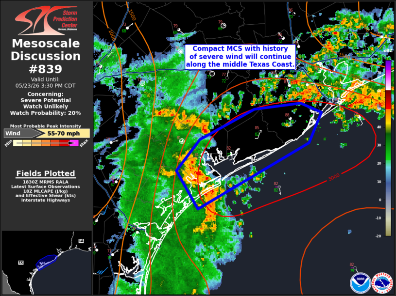
   Mesoscale Discussion 0839
   NWS Storm Prediction Center Norman OK
   0517 PM CDT Sun May 19 2024

   Areas affected...much of Kansas into northwestern Oklahoma

   Concerning...Severe Thunderstorm Watch 260...

   Valid 192217Z - 200015Z

   The severe weather threat for Severe Thunderstorm Watch 260
   continues.

   SUMMARY...A couple of clusters of thunderstorms appear likely to
   continue to gradually evolve and organize during the next couple of
   hours, with severe wind gusts occasionally exceeding 75 mph becoming
   the most prominent severe hazard by 7-8 PM CDT.

   DISCUSSION...Embedded within 30-40 kt southwesterly deep-layer mean
   flow, an ongoing intense supercell has been rightward (eastward)
   propagating toward the Salina KS vicinity.  This motion is roughly
   coincident with a west-southwest to east-northeast oriented warm
   frontal zone, extending along/north of the Interstate 70 corridor
   into northeastern Kansas.  Given enhanced forcing for ascent
   associated with low-level convergence and warm advection along this
   boundary,  and fairly sizable boundary-layer temperature/dew point
   spreads to the south of the front, further upscale growth and
   evolution into a more prominent bowing structure with strong
   damaging surface gusts becoming the primary severe hazards seems
   probable through 23-01Z.

   At the same time, as a low-amplitude short wave trough continues to
   gradually emerge from the southern Rockies, intensifying storms
   along the dryline north of Garden City KS into the Clinton-Sherman
   OK vicinity may continue to increase along consolidating eastward
   propagating outflows, aided by inflow of seasonably moist air
   characterized by large CAPE to around 3000 J/kg.  In the presence of
   seasonably moderate to strong shear, this activity seems likely to
   gradually organize.  The evolution of one or two increasingly
   prominent lower/mid-tropospheric mesoscale vortices appears
   possible, with the quasi-stationary front north of Dodge City into
   the Russell/Salina vicinities one potential focus for strong,
   damaging wind gusts.

   ..Kerr.. 05/19/2024

   ...Please see www.spc.noaa.gov for graphic product...

   ATTN...WFO...EAX...TOP...ICT...OUN...GID...DDC...

   LAT...LON   39669764 39879551 38509541 37709738 36459817 36049924
               36329991 37309965 38230020 38669959 39149846 39669764 


Source link