| Mesoscale Discussion 837 | |
| < Previous MD Next MD > | |

|
|
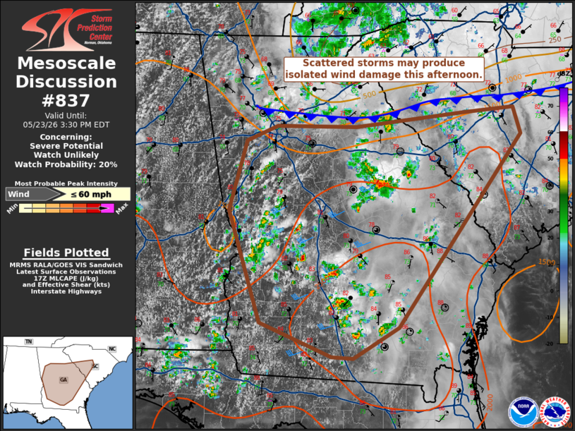
   Mesoscale Discussion 0837
   NWS Storm Prediction Center Norman OK
   1234 PM CDT Sat May 23 2026

   Areas affected...Georgia into central South Carolina

   Concerning...Severe potential...Watch unlikely

   Valid 231734Z - 231930Z

   Probability of Watch Issuance...20 percent

   SUMMARY...Isolated wind damage is possible as scattered convection
   develops this afternoon. Potential for a more organized severe
   threat continues to appear low and a watch is not currently
   anticipated.

   DISCUSSION...Despite weak forcing, scattered thunderstorms are
   likely within a a very moist (low/mid 70s F dewpoints) and weakly
   capped airmass. Mid-level lapse rates are relatively poor (6 C/km
   per 12Z FFC sounding), but around 1.75 in. PWAT values and pockets
   of steeper low-level lapse rates will promote potential for isolated
   water-loaded downbursts and associated wind damage. Storm
   organization is not expected to be substantial and any greater
   potential for wind damage would be tied to localized clustering of
   storm cells.

   ..Wendt/Guyer.. 05/23/2026

   ...Please see www.spc.noaa.gov for graphic product...

   ATTN...WFO...CHS...CAE...GSP...JAX...FFC...TAE...BMX...

   LAT...LON   31358461 32788508 33668482 33858436 33838318 34018154
               34088081 33748069 32488167 31308255 30908322 30928354
               31358461

   MOST PROBABLE PEAK WIND GUST...UP TO 60 MPH
|
|
|
Top/All Mesoscale Discussions/Forecast Products/Home |
|
Source link