| Mesoscale Discussion 835 | |
| < Previous MD | |

|
|
Mesoscale Discussion 0835
NWS Storm Prediction Center Norman OK
0920 AM CDT Sat May 23 2026
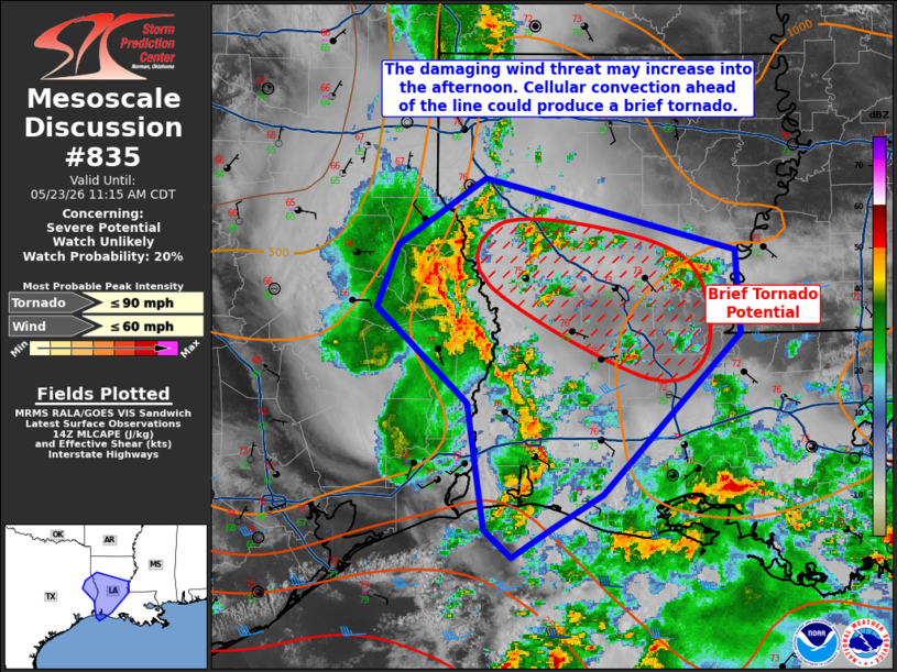
Areas affected...Sabine Valley into central Louisiana
Concerning...Severe potential...Watch unlikely
Valid 231420Z - 231615Z
Probability of Watch Issuance...20 percent
SUMMARY...Isolated damaging winds are possible with a band of
convection moving into Louisiana. A brief tornado may also occur
with cellular convection ahead of the line. A watch is not currently
expected, though observational trends will be monitored.
DISCUSSION...A band of thunderstorms in association with an MCV
continues eastward through the Sabine Valley region this morning.
Occasional strengthening of convective cores has been noted on MRMS
CAPPI imagery. As surface heating occurs ahead of this activity,
isolated wind damage will be possible with the strongest portions of
the line. In central Louisiana, recent radar data from KPOE shows a
couple of supercell structures with at least weak low-level
rotation. Regional VAD profiles do not show very strong low level
shear, but there is likely some localized enhancement in close
proximity to the MCV. A brief tornado is possible with cellular
convection ahead of the MCV/convective line and perhaps within the
line as well. A watch is not currently anticipated, but convective
trends will be monitored into the afternoon.
..Wendt/Guyer.. 05/23/2026
...Please see www.spc.noaa.gov for graphic product...
ATTN...WFO...JAN...LIX...LCH...SHV...
LAT...LON 29399341 29599363 30499377 31199454 31649435 32129363
31599154 31009150 29849264 29599307 29399341
MOST PROBABLE PEAK TORNADO INTENSITY...UP TO 90 MPH
MOST PROBABLE PEAK WIND GUST...UP TO 60 MPH
|
|
|
Top/All Mesoscale Discussions/Forecast Products/Home |
|
Source link