| Mesoscale Discussion 833 | |
| < Previous MD | |

|
|
Mesoscale Discussion 0833
NWS Storm Prediction Center Norman OK
1156 PM CDT Fri May 22 2026
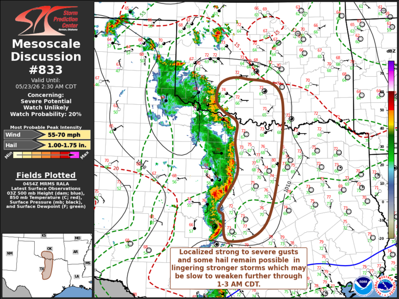
Areas affected...parts of southwestern into south central Oklahoma
through central Texas
Concerning...Severe potential...Watch unlikely
Valid 230456Z - 230730Z
Probability of Watch Issuance...20 percent
SUMMARY...Strong lingering storms may be slow to undergo substantive
further weakening, and could continue to pose a risk for localized
strong to severe gusts and some hail through 1-3 AM CDT.
DISCUSSION...Near the leading edge of a broad and otherwise
weakening eastward propagating, convectively generated surface cold
pool, a narrow corridor of 2-4 mb 2-hourly surface pressure rises
has developed as vigorous convective development persists. This is
being aided by continuing inflow of seasonably moist boundary-layer
air characterized by sizable CAPE in excess of 2000 J/kg, as lift
remains sufficient to overcome increasing inhibition with surface
cooling.
How long this persists remains unclear. Mid/upper support does not
appear particularly strong, and vertical shear is generally weak, in
the presence of 10-15 kt westerly deep-layer mean wind fields.
However, given the current strength of the ongoing convective
development, and the potential instability present ahead of activity
across and east of the I-35 corridor, storms may be slow to undergo
substantive further weakening as it slowly develops eastward through
06-08Z.
..Kerr/Thompson.. 05/23/2026
...Please see www.spc.noaa.gov for graphic product...
ATTN...WFO...FWD...OUN...EWX...
LAT...LON 30869831 31569847 31689860 32589806 33389811 33909806
34189847 34479870 34939854 35029781 34499666 31439710
30869831
MOST PROBABLE PEAK WIND GUST...55-70 MPH
MOST PROBABLE PEAK HAIL SIZE...1.00-1.75 IN
|
|
|
Top/All Mesoscale Discussions/Forecast Products/Home |
|
Source link