| Mesoscale Discussion 832 | |
| < Previous MD | |

|
|
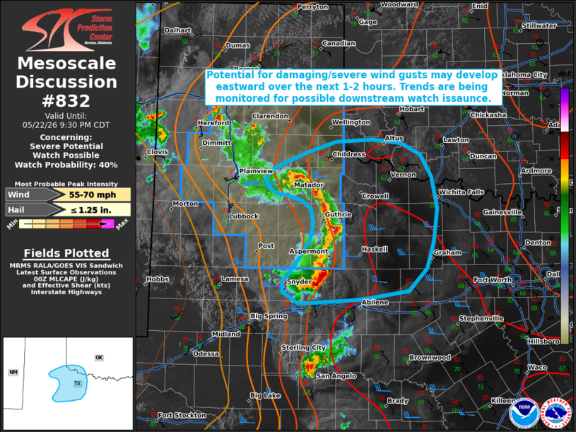
   Mesoscale Discussion 0832
   NWS Storm Prediction Center Norman OK
   0759 PM CDT Fri May 22 2026

   Areas affected...portions of the Texas Big Country

   Concerning...Severe potential...Watch possible

   Valid 230059Z - 230230Z

   Probability of Watch Issuance...40 percent

   SUMMARY...Potential for damaging/severe wind gusts may develop
   eastward in association with a loosely-organized band of convection.
   Trends are being monitored for potential downstream watch issuance.

   DISCUSSION...Convective coverage has gradually increased over the
   past hour across portions of northwest Texas along the eastern edge
   of a consolidated cold pool. While cooling surface temperatures and
   increasing inhibition are noted ahead of this convection via the
   latest surface observations and objective analysis, 2000-3000 J/kg
   MLCAPE and modest westerly effective shear of 20-30 kts may support
   the continued eastward propagation of this developing convective
   band. Should this occur, the primary severe threat would be
   damaging/severe wind gusts; although, it remains uncertain as to
   whether this band will attain more than loose organization. Some
   risk for isolated large hail may also persist with the strongest
   updrafts.

   ..Chalmers/Thompson.. 05/23/2026

   ...Please see www.spc.noaa.gov for graphic product...

   ATTN...WFO...FWD...OUN...SJT...LUB...MAF...

   LAT...LON   32640096 32780096 32880085 33110069 33350053 33550048
               33760052 33870066 33930089 33970109 34030119 34150125
               34300109 34520057 34650011 34699952 34639907 34499877
               34189859 33769849 33329856 32959867 32659896 32579955
               32549983 32480071 32640096

   MOST PROBABLE PEAK WIND GUST...55-70 MPH
   MOST PROBABLE PEAK HAIL SIZE...UP TO 1.25 IN
|
|
|
Top/All Mesoscale Discussions/Forecast Products/Home |
|
Source link