| Mesoscale Discussion 831 | |
| < Previous MD | |

|
|
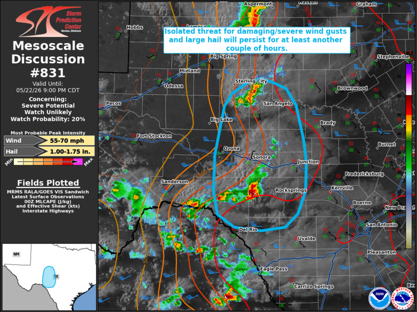
   Mesoscale Discussion 0831
   NWS Storm Prediction Center Norman OK
   0730 PM CDT Fri May 22 2026

   Areas affected...portions of Edwards Plateau into south-central
   Texas

   Concerning...Severe potential...Watch unlikely

   Valid 230030Z - 230200Z

   Probability of Watch Issuance...20 percent

   SUMMARY...Isolated thunderstorms will continue to pose a risk for
   damaging/severe wind gusts and large hail for at least another
   couple of hours. Watch issuance remains unlikely.

   DISCUSSION...Isolated thunderstorms remain ongoing across portions
   of Edwards Plateau along/ahead of a dryline. The environment
   preceding this convection remains moderately to strongly unstable
   with 2000-3000+ J/kg MLCAPE analyzed via the latest objective
   analysis. 20-30 kts of effective shear is sufficient to continue
   supporting transient supercell structures and multicells/clusters.
   Coupled with steep low- and mid-level lapse rates (as sampled by the
   00z DRT observed sounding), this will continue to promote a risk for
   damaging/severe wind gusts and large hail with ongoing convection.

   While the onset of low-level nocturnal cooling/stabilization should
   begin to temper convective activity/intensity, there is some
   potential for one or more convective clusters to persist for another
   couple of hours, especially the storms now near Edwards County where
   stronger westerly flow aloft is supporting greater effective shear
   (35+ kts), which may promote locally greater severe potential.

   Given the isolated nature of ongoing convection, watch issuance
   remains unlikely at this time. Trends will continue to be monitored,
   however.

   ..Chalmers/Thompson.. 05/23/2026

   ...Please see www.spc.noaa.gov for graphic product...

   ATTN...WFO...EWX...SJT...

   LAT...LON   30060137 30650135 31480117 31690102 31860072 31920051
               31880027 31779996 31499977 30919964 30549958 30059960
               29679976 29469999 29400046 29450096 29670128 30060137

   MOST PROBABLE PEAK WIND GUST...55-70 MPH
   MOST PROBABLE PEAK HAIL SIZE...1.00-1.75 IN
|
|
|
Top/All Mesoscale Discussions/Forecast Products/Home |
|
Source link