| Mesoscale Discussion 827 | |
| < Previous MD | |
|
|
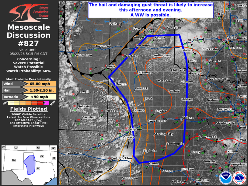
   Mesoscale Discussion 0827
   NWS Storm Prediction Center Norman OK
   0309 PM CDT Fri May 22 2026

   Areas affected...portions of West Texas...the Texas Panhandle and
   far southwestern Oklahoma

   Concerning...Severe potential...Watch possible

   Valid 222009Z - 222215Z

   Probability of Watch Issuance...60 percent

   SUMMARY...Thunderstorm initiation is likely over the next several
   hours across portions of far eastern NM and West TX. A mix of multi
   cells and transient supercells may pose a risk for damaging winds
   and hail. A WW is possible.

   DISCUSSION...As of 20 UTC, regional visible imagery showed a
   building cumulus field across portions of far eastern NM, West TX
   and the southern TX Panhandle. Towers within this cu field have
   steadily deepened  indicating erosion of remaining inhibition
   shortly. Amid strong diurnal heating and weak ascent from a
   subtropical disturbance aloft, area RAP and Observed AMA soundings
   show surface temperatures now warming into the upper 80s to low 90s
   F, which will exceed convective temperature in the next couple of
   hours. This should support scattered thunderstorm development this
   afternoon.

   While a gradient in surface dewpoints is evident in area obs, steep
   low and mid-level lapse rates are supporting sufficient buoyancy
   (1000-2000 J/kg of MLCAPE) for strong updrafts. Deep-layer shear is
   not overly large, generally 20-30 kt. This suggests a mixed mode of
   multi cell clusters and transient supercells. Hail will be possible
   with the stronger storms. Numerous storm interactions and the modest
   low-level moisture favoring stronger downdrafts and cold pool
   development should also result in fairly rapid upscale growth into
   one or more clusters or an MCS. Thus, the risk for damaging winds is
   also possible, and expected to increase with time.

   Current expectations are for storms to develop withing the warmer
   and more well-mixed air mass over West TX and the southern Panhandle
   before expanding in coverage farther east. Additional CI remains
   possible along the southward moving cold front farther north.
   However, this has become less certain in recent CAM runs. The severe
   risk should gradually increase this afternoon and evening with a WW
   possible in the next couple of hours.

   ..Lyons/Hart.. 05/22/2026

   ...Please see www.spc.noaa.gov for graphic product...

   ATTN...WFO...OUN...SJT...LUB...AMA...MAF...

   LAT...LON   33170221 34080303 35660128 35729976 34819947 34439941
               33169947 32609951 31539963 31160007 30890080 30800162
               31080186 31530183 32640199 33170221

   MOST PROBABLE PEAK TORNADO INTENSITY...UP TO 90 MPH
   MOST PROBABLE PEAK WIND GUST...65-80 MPH
   MOST PROBABLE PEAK HAIL SIZE...1.50-2.50 IN
|
|
|
Top/All Mesoscale Discussions/Forecast Products/Home |
|
Source link