| Mesoscale Discussion 826 | |
| < Previous MD Next MD > | |
|
|
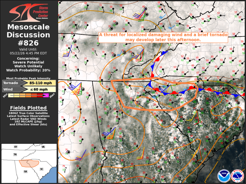
   Mesoscale Discussion 0826
   NWS Storm Prediction Center Norman OK
   0109 PM CDT Fri May 22 2026

   Areas affected...Parts of north GA into Upstate SC

   Concerning...Severe potential...Watch unlikely

   Valid 221809Z - 222045Z

   Probability of Watch Issuance...20 percent

   SUMMARY...A threat for localized damaging wind and a brief tornado
   may develop later this afternoon.

   DISCUSSION...A nearly stationary baroclinic zone is in place near
   the NC/SC border early this afternoon. South of the primary thermal
   gradient, backed surface winds are observed within a broader
   confluence zone from parts of north GA into Upstate SC. Continued
   heating/destabilization is expected to result in additional
   thunderstorm development across this area through the afternoon.
   This area will be somewhat removed from stronger low/midlevel flow
   across parts of the TN/OH Valleys, but moderate buoyancy and locally
   enhanced deep-layer shear within the zone of backed surface winds
   may support at least transient storm organization, and a marginal
   supercell or two cannot be ruled out.

   Weak midlevel lapse rates will tend to limit updraft intensity and
   will temper the magnitude of the threat, but localized damaging wind
   could accompany the strongest storms. A brief tornado also cannot be
   ruled out, given the presence of modestly enhanced low-level
   shear/SRH within a very moist environment.

   ..Dean/Hart.. 05/22/2026

   ...Please see www.spc.noaa.gov for graphic product...

   ATTN...WFO...CAE...GSP...MRX...FFC...

   LAT...LON   35008478 35138282 34958212 34928120 34748104 34448115
               34328131 34088178 33968220 33998349 34088420 34828471
               35008478

   MOST PROBABLE PEAK TORNADO INTENSITY...85-110 MPH
   MOST PROBABLE PEAK WIND GUST...UP TO 60 MPH
|
|
|
Top/All Mesoscale Discussions/Forecast Products/Home |
|
Source link