| Mesoscale Discussion 825 | |
| < Previous MD | |
|
|
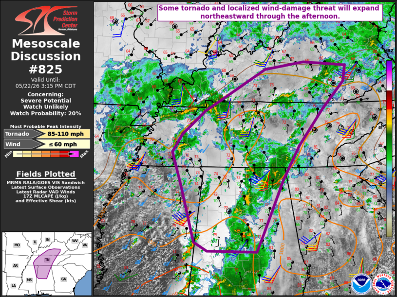
   Mesoscale Discussion 0825
   NWS Storm Prediction Center Norman OK
   1248 PM CDT Fri May 22 2026

   Areas affected...Parts of northeast MS...central/northern
   AL...middle/eastern TN and central/eastern KY

   Concerning...Severe potential...Watch unlikely

   Valid 221748Z - 222015Z

   Probability of Watch Issuance...20 percent

   SUMMARY...Some tornado and localized wind-damage threat will expand
   northeastward through the afternoon.

   DISCUSSION...Within a broad area of convection covering much of AL,
   occasional low-level rotation continues to be noted within embedded
   cells, with an apparent recent tornado southwest of Birmingham. Some
   strengthening of deep-layer flow has been noted from the KHTX VWP,
   though deep-layer shear (generally around 30 kt) continues to be
   rather marginal for organized convection. Modest buoyancy and weak
   midlevel lapse rates will continue to hamper updraft intensity, but
   favorable low-level SRH within the very moist environment will
   continue to support at least a brief-tornado threat across
   central/northern AL.

   Farther north, filtered heating is underway across middle TN into
   southeast KY, though MLCAPE will likely remain modest through the
   afternoon. As stronger low-level flow/shear spreads northeastward in
   conjunction with an ejecting midlevel shortwave trough, some threat
   for marginal supercells and brief tornadoes may expand into a larger
   portion of middle/eastern TN and central/eastern KY. Localized
   damaging winds will also be possible.

   The need for watch issuance remains uncertain, due to the
   potentially limited magnitude and coverage of the threat. Trends
   will continue to be monitored for a more general uptick in storm
   intensity and organization through the afternoon.

   ..Dean/Hart.. 05/22/2026

   ...Please see www.spc.noaa.gov for graphic product...

   ATTN...WFO...MRX...JKL...FFC...LMK...OHX...BMX...HUN...PAH...
   MEG...JAN...

   LAT...LON   32898796 33118836 34538876 35368905 35828875 36428804
               36638764 37458619 37648499 37548370 37138376 36468441
               35548515 34688565 33308627 32878647 32898796

   MOST PROBABLE PEAK TORNADO INTENSITY...85-110 MPH
   MOST PROBABLE PEAK WIND GUST...UP TO 60 MPH
|
|
|
Top/All Mesoscale Discussions/Forecast Products/Home |
|
Source link