| Mesoscale Discussion 823 | |
| < Previous MD | |
|
|
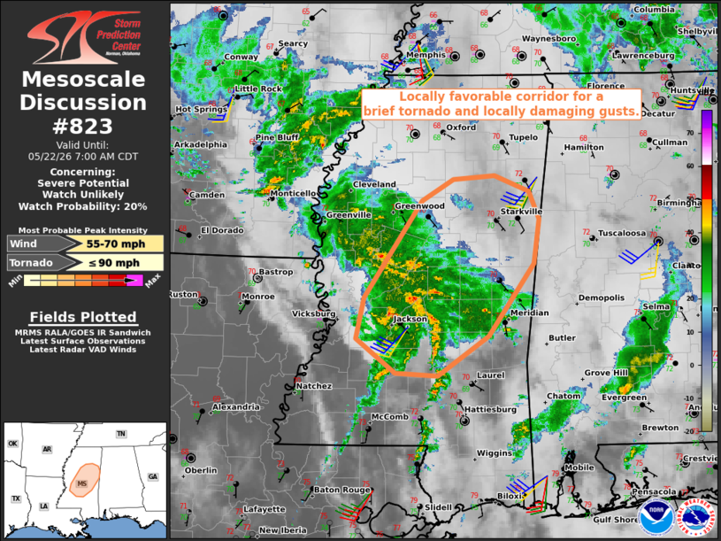
   Mesoscale Discussion 0823
   NWS Storm Prediction Center Norman OK
   0506 AM CDT Fri May 22 2026

   Areas affected...Parts of central Mississippi

   Concerning...Severe potential...Watch unlikely

   Valid 221006Z - 221200Z

   Probability of Watch Issuance...20 percent

   SUMMARY...A brief tornado and locally damaging gusts remain
   possible.

   DISCUSSION...Preceding a midlevel wave approaching the lower MS
   Valley, convection is evolving within low-level confluence bands in
   central MS -- where a moist air mass (lower 70s dewpoints) is in
   place. The JAN VWP is sampling a gradually strengthening low-level
   jet (around 40 kt at 1 km AGL) and an associated clockwise-curved
   low-level hodograph (around 200 m2/s2 0-1 km SRH). Despite weak
   buoyancy, the rich boundary-layer moisture and enhanced streamwise
   vorticity are contributing to a locally favorable environment for
   transient, low-topped supercell structures. A brief tornado was
   reported at 938 UTC southwest of Jackson, MS, and an additional
   brief tornado and locally damaging gusts will remain possible
   beneath the core of the 30-40-kt LLJ as it translates northward
   across central MS.

   ..Weinman/Smith.. 05/22/2026

   ...Please see www.spc.noaa.gov for graphic product...

   ATTN...WFO...MEG...JAN...

   LAT...LON   32149064 32599053 33638980 33868940 33918887 33738843
               33448829 32968837 32178894 31748960 31789013 32149064

   MOST PROBABLE PEAK TORNADO INTENSITY...UP TO 90 MPH
   MOST PROBABLE PEAK WIND GUST...55-70 MPH
|
|
|
Top/All Mesoscale Discussions/Forecast Products/Home |
|
Source link