|
|
| Mesoscale Discussion 815 | |
| < Previous MD | |

|
|
   Mesoscale Discussion 0815
   NWS Storm Prediction Center Norman OK
   0231 PM CDT Fri May 17 2024

   Areas affected...southern Alabama into southwest Georgia...and parts
   of the Florida Panhandle

   Concerning...Severe potential...Watch likely

   Valid 171931Z - 172200Z

   Probability of Watch Issuance...80 percent

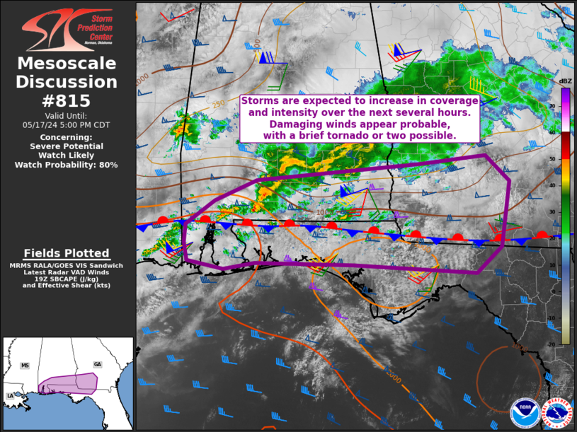
   SUMMARY...Storms will likely increase in coverage and intensity over
   the next few hours, with damaging winds most likely. A brief tornado
   or two will be possible.

   DISCUSSION...Surface analysis shows a stationary front extending
   roughly from far southern MS across the AL/FL border and toward the
   GA/FL border. Observational trends currently indicate little change
   in wind direction along the front, however, some northward
   progression of the boundary is expected as southerly winds over 30
   kt persist just off the surface.

   The 18Z LIX sounding shows a very moist and unstable air mass with
   PWAT over 2.00" and SBCAPE over 3000 J/kg. Moderate deep-layer
   westerly flow exists as well with around 50 kt at 500 mb.

   Latest radar trends show convection increasing along the stationary
   front from southern MS into southern AL. Echo tops are gradually
   increasing, and this trend should continue, especially with cells
   near or just on the warm side of the boundary.

   Given moderate westerly flow and favorable deep layer shear, a few
   bowing structures are anticipated, producing damaging winds.
   Enhanced shear along the east-west oriented front may support
   storm-scale rotation with a brief tornado or two possible through
   early evening as cells evolve east.

   ..Jewell/Hart.. 05/17/2024

   ...Please see www.spc.noaa.gov for graphic product...

   ATTN...WFO...FFC...TAE...BMX...MOB...

   LAT...LON   30938835 31268789 31558723 31788463 31898355 31528317
               30638331 30278371 30388569 30408725 30328774 30438833
               30688837 30938835
|
|
|
Top/All Mesoscale Discussions/Forecast Products/Home |
|


