| Mesoscale Discussion 814 | |
| < Previous MD | |

|
|
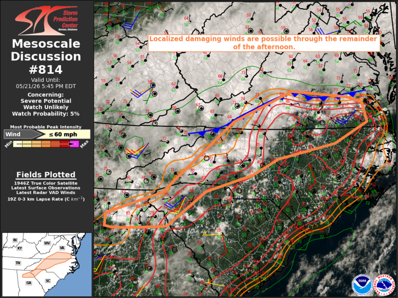
   Mesoscale Discussion 0814
   NWS Storm Prediction Center Norman OK
   0252 PM CDT Thu May 21 2026

   Areas affected...Southern Appalachians into parts of southern
   VA/northern NC

   Concerning...Severe potential...Watch unlikely

   Valid 211952Z - 212145Z

   Probability of Watch Issuance...5 percent

   SUMMARY...Localized damaging winds are possible through the
   remainder of the afternoon.

   DISCUSSION...Scattered thunderstorms have developed this afternoon
   from north GA into southern VA. Convection is generally disorganized
   within a modestly unstable and weakly sheared environment, though
   occasionally robust cells have developed in the vicinity of a cold
   front across southern VA. Relatively strong heating and steepening
   of low-level lapse rates has occurred from the southern Appalachians
   to areas of southern VA/northern NC along/south of the cold front,
   which will result in some potential for localized damaging outflow
   winds in association with the strongest updrafts/downdrafts.
   Increasing storm coverage may result in a southward-acceleration of
   the cold front across southern VA/northern NC through late
   afternoon, which could result in a broader area of strong but
   generally subsevere gusts and localized wind-damage potential.

   ..Dean/Hart.. 05/21/2026

   ...Please see www.spc.noaa.gov for graphic product...

   ATTN...WFO...AKQ...RAH...RNK...GSP...FFC...

   LAT...LON   34988161 34108276 34048405 34058444 34088462 34398459
               34958292 36728077 37487898 37327730 37177683 36697668
               36177767 35797942 35418018 34988161

   MOST PROBABLE PEAK WIND GUST...UP TO 60 MPH
|
|
|
Top/All Mesoscale Discussions/Forecast Products/Home |
|
Source link