| Mesoscale Discussion 812 | |
| < Previous MD | |
|
|
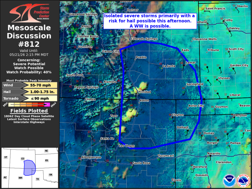
   Mesoscale Discussion 0812
   NWS Storm Prediction Center Norman OK
   0110 PM CDT Thu May 21 2026

   Areas affected...portions of southeastern Colorado Northern New
   Mexico and the western Texas/Oklahoma Panhandles

   Concerning...Severe potential...Watch possible

   Valid 211810Z - 212015Z

   Probability of Watch Issuance...40 percent

   SUMMARY...Initial high-based updrafts developing over the Sangre De
   Cristos and Raton Mesa should gradually intensify as the atmosphere
   continues to destabilize. Isolated supercells with hail are the
   primary hazard. Uncertainty remains regarding storm coverage and
   intensity but a watch is possible.

   DISCUSSION...As of 1810 UTC, regional visible imagery and surface
   observations showed initial updrafts developing over the higher
   terrain of southeastern CO and northern NM. Supported by strong
   diurnal heating amid a broad upslope flow regime south a broad upper
   low over the northern Rockies, these initial convective cells are
   very high-based with T/TD spreads of 20-30 degrees suggesting they
   are rooted near the top of a well mixed and weakly unstable boundary
   layer. Farther east, more substantial surface moisture is in place
   with dewpoints in the mid 40s to mid 50s F. As these incipient
   updrafts are advected off the higher terrain by 30-40 kt of
   west/southwesterly flow aloft, they will encounter more robust
   destabilization with SPC mesoanalysis showing 1000-1500 J/kg of
   MUCAPE present. This should allow for gradual intensification with
   time/eastward extent.

   While deep-layer flow is not overly strong, VADs and area RAP
   sounding show sufficient bulk shear for supercells and organized
   multicells. With steep low and mid-level lapse rates, hail is
   possible with the stronger storms. Some damaging wind threat may
   also evolve given the warming boundary layer.

   The exact timing and convective evolution remains unclear this
   afternoon as overall forcing for ascent is weaker than farther
   north. Recent CAM guidance shows these initial storms consolidating
   into a couple supercells before drifting east/southeast this
   afternoon. This should favor a general increase in the severe risk
   with time. However, the more limited thermodynamic and kinematic
   environment does cast some uncertainty on the spatial extent and
   intensity of the convection this afternoon. Given all this,
   conditions are being monitored for a possible WW this afternoon.

   ..Lyons/Hart.. 05/21/2026

   ...Please see www.spc.noaa.gov for graphic product...

   ATTN...WFO...DDC...GLD...AMA...PUB...BOU...ABQ...

   LAT...LON   38590293 37880223 36970199 36290212 35740247 35470400
               35460474 35690517 37880505 38550521 38800428 38750359
               38590293

   MOST PROBABLE PEAK TORNADO INTENSITY...UP TO 90 MPH
   MOST PROBABLE PEAK WIND GUST...55-70 MPH
   MOST PROBABLE PEAK HAIL SIZE...1.00-1.75 IN
|
|
|
Top/All Mesoscale Discussions/Forecast Products/Home |
|
Source link