| Mesoscale Discussion 805 | |
| < Previous MD | |
|
|
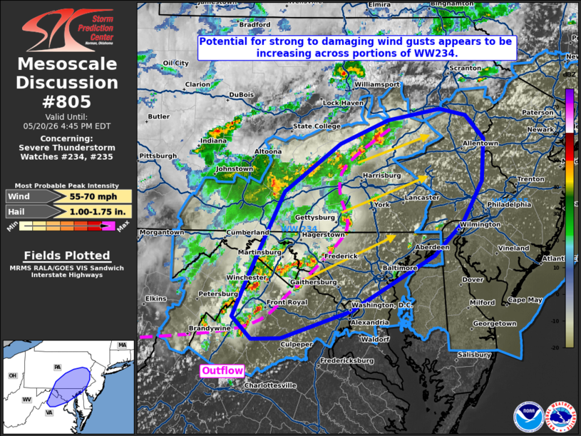
Mesoscale Discussion 0805 NWS Storm Prediction Center Norman OK 0209 PM CDT Wed May 20 2026 Areas affected...portions of the Mid-Atlantic Concerning...Severe Thunderstorm Watch 234...235... Valid 201909Z - 202045Z The severe weather threat for Severe Thunderstorm Watch 234, 235 continues. SUMMARY...Potential for damaging wind gusts and isolated large hail is increasing across portions Severe Thunderstorm Watch 234 and will expand into downstream WW 235 through the afternoon. DISCUSSION...Convective coverage has increased across portions WW234 over the past 1-2 hours amid continued destabilization ahead of an approaching cold front, with two reports of wind damage noted across far southern Pennsylvania. Recent radar trends suggest that some upscale growth/clustering of convection is ongoing along various outflow boundaries. The environment downstream of this convection has continued to destabilize, with latest objective analysis depicting 1000-1500+ J/kg MLCAPE across the region. Continued insolation is also yielding steepening low-level lapse rates and well-mixed boundary layer profiles (evident in recent regional ACARS profiles and latest surface observations, respectively), with surface dewpoint depressions approaching/exceeding 25-30 F. With further convective clustering expected, this is expected to yield increasing potential for damaging wind gusts across the eastern portions of WW234 through the afternoon, with activity eventually forecast to spreading downstream into WW235. Latest high-res guidance (including recent WoFS runs) also depicts this increasing potential. ..Chalmers.. 05/20/2026 ...Please see www.spc.noaa.gov for graphic product... ATTN...WFO...PHI...BGM...CTP...LWX... LAT...LON 38877702 38597798 38587838 38817865 39307840 40147793 40667717 40907651 41027579 40957542 40707517 40257520 39827546 39477586 38877702 MOST PROBABLE PEAK WIND GUST...55-70 MPH MOST PROBABLE PEAK HAIL SIZE...1.00-1.75 IN |
|
|
Top/All Mesoscale Discussions/Forecast Products/Home |
|
Source link