| Mesoscale Discussion 80 | |
| < Previous MD | |

|
|
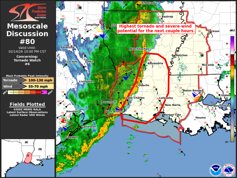
Mesoscale Discussion 0080 NWS Storm Prediction Center Norman OK 0902 PM CST Sat Feb 14 2026 Areas affected...Parts of southern/central Louisiana Concerning...Tornado Watch 6... Valid 150302Z - 150400Z The severe weather threat for Tornado Watch 6 continues. SUMMARY...The severe threat will be maximized in parts of south-central Louisiana for the next couple hours -- within Tornado Watch #6. DISCUSSION...A north/south-oriented QLCS with embedded mesovorticies is tracking eastward into south-central LA at 35-40 kt. At least one or two brief tornadoes have accompanied these circulations near the Fort Polk, LA radar during the last hour. While pre-convective buoyancy remains limited, a narrow plume of middle/upper 60s dewpoints streaming northward ahead of the line will continue to destabilize the inflow for the approaching storms. This, combined with large clockwise-curved hodographs (around 300-400 m2/s2 low-level SRH), will continue to promote mesovorticies with a risk of tornadoes and locally enhanced wind damage. ..Weinman.. 02/15/2026 ...Please see www.spc.noaa.gov for graphic product... ATTN...WFO...JAN...LIX...LCH...SHV... LAT...LON 29889339 30749286 31509260 31699247 31669204 31499177 31149164 30439166 29769202 29489246 29629333 29889339 MOST PROBABLE PEAK TORNADO INTENSITY...100-130 MPH MOST PROBABLE PEAK WIND GUST...55-70 MPH |
|
|
Top/All Mesoscale Discussions/Forecast Products/Home |
|
Source link