| Mesoscale Discussion 791 | |
| < Previous MD | |

|
|
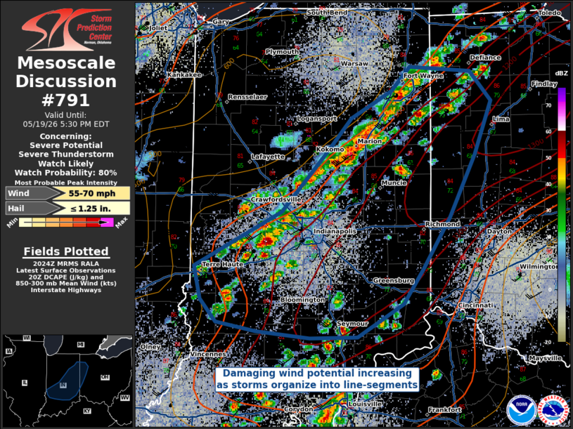
   Mesoscale Discussion 0791
   NWS Storm Prediction Center Norman OK
   0326 PM CDT Tue May 19 2026

   Areas affected...Central Indiana into Western Ohio

   Concerning...Severe potential...Severe Thunderstorm Watch likely

   Valid 192026Z - 192130Z

   Probability of Watch Issuance...80 percent

   SUMMARY...As convective coverage has increased this afternoon across
   central and northern Indiana, it has gradually begun to organize
   into line-segments/clusters. As these storms continue to organize,
   they could pose a damaging wind threat... particularly with any
   bowing line segments that may develop.

   DISCUSSION...Convective coverage has continued to increase over
   central and northern Indiana, especially over the last half hour.
   Recent MRMS trends show loose organization into line segments ahead
   of an environment characterized by strong DCAPE, steep low-level
   lapse rates, and well-mixed boundary layer profiles. While there is
   some uncertainty to which degree these storms will organize due to
   the relative lack of deep-layer shear, the environment supports the
   potential for damaging straight-line thunderstorm winds. This threat
   will be maximized along the leading edge of any bowing segments that
   develop.

   ..Halbert/Hart.. 05/19/2026

   ...Please see www.spc.noaa.gov for graphic product...

   ATTN...WFO...ILN...IWX...IND...

   LAT...LON   39508749 39988650 40498599 40798571 41048525 41248503
               41218434 40958411 40488429 39928458 39468489 39168512
               38888564 38878618 38928679 39018723 39208741 39508749

   MOST PROBABLE PEAK WIND GUST...55-70 MPH
   MOST PROBABLE PEAK HAIL SIZE...UP TO 1.25 IN
|
|
|
Top/All Mesoscale Discussions/Forecast Products/Home |
|
Source link