| Mesoscale Discussion 79 | |
| < Previous MD | |

|
|
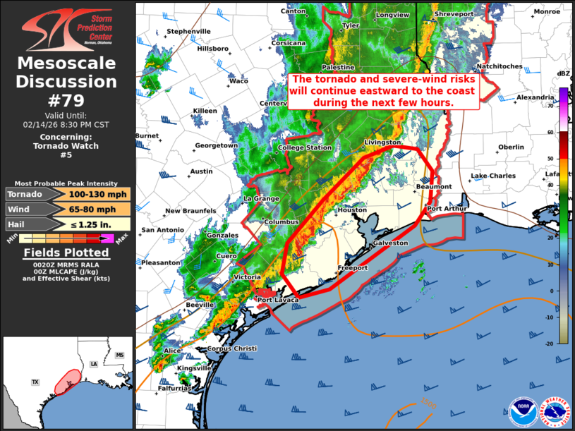
Mesoscale Discussion 0079 NWS Storm Prediction Center Norman OK 0623 PM CST Sat Feb 14 2026 Areas affected...Parts of the Middle and Upper Texas Coast Concerning...Tornado Watch 5... Valid 150023Z - 150230Z The severe weather threat for Tornado Watch 5 continues. SUMMARY...The risk of severe wind gusts and a couple tornadoes will continue eastward to the coast during the next few hours -- within Tornado Watch #5. DISCUSSION...The latest radar data from KHGX depicts an organized squall line moving eastward along a surface cold front at around 35-40 kt toward the Middle and Upper TX Coast. Ahead of the line, the HGX VWP is sampling a 40 kt low-level jet, which is contributing to large clockwise hodograph curvature (250-300 m2/s2 effective SRH). While the frontal forcing and 50-60 kt of line-parallel effective shear is promoting a continued linear mode (with a severe-wind risk), the ample streamwise vorticity and upper 60s to near 70 boundary-layer dewpoints is also favoring embedded circulations/supercell structures and a tornado risk. The risk of severe wind gusts and possibly a brief tornado or two will continue to the coast during the next few hours -- within Tornado Watch #5. ..Weinman.. 02/15/2026 ...Please see www.spc.noaa.gov for graphic product... ATTN...WFO...LCH...HGX... LAT...LON 29359614 29969556 30569492 30729444 30679405 30369381 29949385 29609409 28729545 28609594 28929622 29359614 MOST PROBABLE PEAK TORNADO INTENSITY...100-130 MPH MOST PROBABLE PEAK WIND GUST...65-80 MPH MOST PROBABLE PEAK HAIL SIZE...UP TO 1.25 IN |
|
|
Top/All Mesoscale Discussions/Forecast Products/Home |
|
Source link