| Mesoscale Discussion 787 | |
| < Previous MD | |

|
|
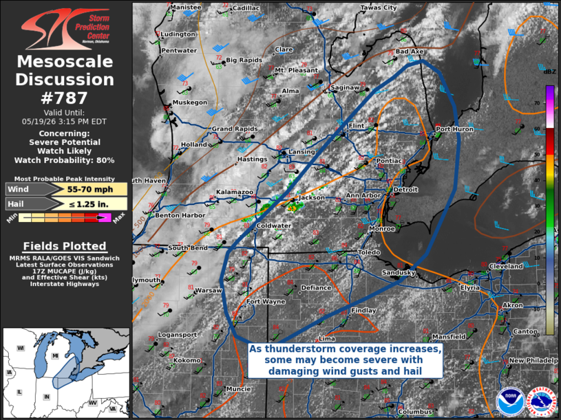
   Mesoscale Discussion 0787
   NWS Storm Prediction Center Norman OK
   1244 PM CDT Tue May 19 2026

   Areas affected...Northern Indiana/Ohio into Southeastern Michigan

   Concerning...Severe potential...Watch likely

   Valid 191744Z - 191915Z

   Probability of Watch Issuance...80 percent

   SUMMARY...Thunderstorms capable of damaging wind gusts are
   anticipated this afternoon across portions of northern Indiana/Ohio
   into southeastern Michigan. A severe thunderstorm watch is likely.

   DISCUSSION...Current expectations are that thunderstorm coverage
   will continue to increase this afternoon in an environment
   characterized by steep low-level lapse rates, strong buoyancy, and
   modest deep-layer shear. This should support storm organization into
   linear segments capable of damaging wind gusts and hail, with the
   highest threat for damaging winds anticipated where any bowing line
   segments may develop.

   ..Halbert/Hart.. 05/19/2026

   ...Please see www.spc.noaa.gov for graphic product...

   ATTN...WFO...CLE...ILN...DTX...IWX...GRR...

   LAT...LON   42378214 41688256 41408292 41228343 41038396 40668481
               40808525 41058539 41408547 41708537 41828525 42358455
               42818403 43218355 43448327 43578301 43698280 43758257
               43618234 43268212 42908207 42378214

   MOST PROBABLE PEAK WIND GUST...55-70 MPH
   MOST PROBABLE PEAK HAIL SIZE...UP TO 1.25 IN
|
|
|
Top/All Mesoscale Discussions/Forecast Products/Home |
|
Source link