|
|
| Mesoscale Discussion 784 | |
| < Previous MD Next MD > | |

|
|
   Mesoscale Discussion 0784
   NWS Storm Prediction Center Norman OK
   0453 PM CDT Tue May 14 2024

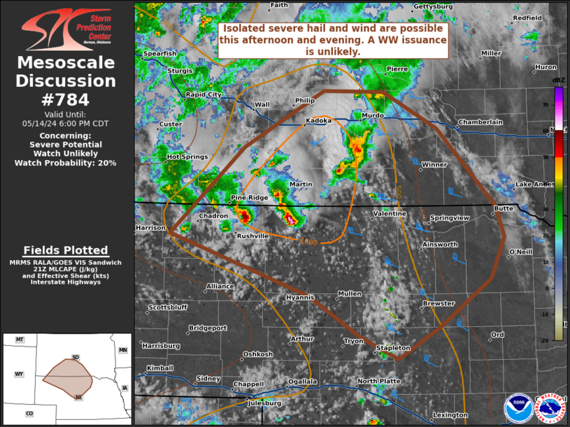
   Areas affected...portions of southern South Dakota into northern
   Nebraska

   Concerning...Severe potential...Watch unlikely

   Valid 142153Z - 142300Z

   Probability of Watch Issuance...20 percent

   SUMMARY...Storms should continue with an isolated severe wind and
   hail threat through the afternoon. A WW issuance is not expected.

   DISCUSSION...Clusters of thunderstorms have been maturing into
   multicells and transient supercells over the past couple of hours
   along the SD/NE border. Ahead of these storms, temperatures have
   warmed to around 80 F amid upper 40s F dewpoints (locally higher
   along a surface boundary), supporting around 1000 J/kg MLCAPE (per
   latest mesoanalysis and RAP forecast soundings). Deep-layer shear is
   relatively weak, but steep tropospheric lapse rates suggest that
   isolated instances of severe hail and wind may accompany the
   stronger updrafts, particularly with any sustained supercell
   structures this afternoon and evening. Given the isolated nature of
   the severe threat, a WW issuance is not anticipated.

   ..Squitieri/Smith.. 05/14/2024

   ...Please see www.spc.noaa.gov for graphic product...

   ATTN...WFO...FSD...ABR...LBF...UNR...CYS...

   LAT...LON   42690338 43590235 44180122 44180039 43799962 42999880
               42669868 42239888 41749959 41410018 41640072 42060141
               42360235 42690338
|
|
|
Top/All Mesoscale Discussions/Forecast Products/Home |
|


