| Mesoscale Discussion 777 | |
| < Previous MD | |

|
|
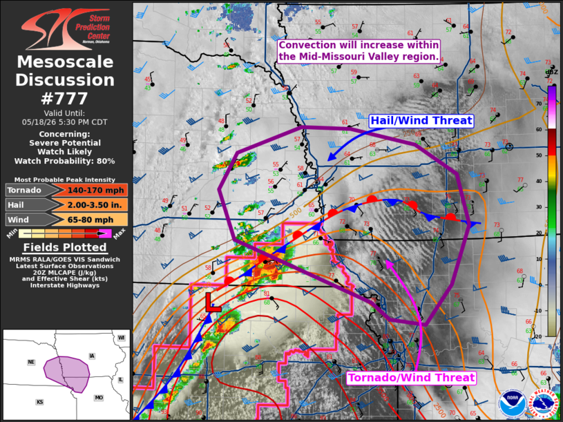
Mesoscale Discussion 0777 NWS Storm Prediction Center Norman OK 0329 PM CDT Mon May 18 2026 Areas affected...Portions of Mid-Missouri Valley Region Concerning...Severe potential...Watch likely Valid 182029Z - 182230Z Probability of Watch Issuance...80 percent SUMMARY...The threat for severe storms will increase into the evening. Tornadoes will remain possible along the Iowa/Missouri border with hail becoming the primary hazard with northward extent. One or more watches will be needed this afternoon. DISCUSSION...At least modest airmass recovery has occurred along the Iowa/Missouri border region. Dewpoints have risen into the mid 60s to low 70s F in some locations. North of the boundary, steep mid-level lapse rates are in place per the 18Z OAX sounding. As the shortwave trough moves into the area, additional storm development is likely. This is already occurring in eastern Nebraska. Furthermore, additional theta-e advection ahead of the ongoing supercells in north-central Kansas and southeast Nebraska will allow a tornado threat to persist northeast of PDS WW 222. One or more watches will be needed this afternoon. The tornado threat will be maximized south of the boundary with a transition to more of a hail threat with elevated storms to the north. ..Wendt/Hart.. 05/18/2026 ...Please see www.spc.noaa.gov for graphic product... ATTN...WFO...DMX...EAX...OAX...TOP...GID... LAT...LON 40569724 41199752 41659722 41989617 41969535 41769429 41399360 40759341 40029371 39529415 39589472 39809501 40569724 MOST PROBABLE PEAK TORNADO INTENSITY...140-170 MPH MOST PROBABLE PEAK WIND GUST...65-80 MPH MOST PROBABLE PEAK HAIL SIZE...2.00-3.50 IN |
|
|
Top/All Mesoscale Discussions/Forecast Products/Home |
|
Source link