| Mesoscale Discussion 769 | |
| < Previous MD | |

|
|
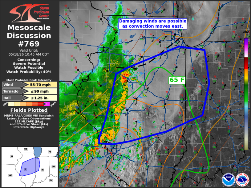
   Mesoscale Discussion 0769
   NWS Storm Prediction Center Norman OK
   0840 AM CDT Mon May 18 2026

   Areas affected...Central Illinois into western Indiana

   Concerning...Severe potential...Watch possible

   Valid 181340Z - 181545Z

   Probability of Watch Issuance...40 percent

   SUMMARY...Damaging wind potential will probably increase in parts of
   central Illinois/western Indiana. Depending on convective trends, a
   watch may be need. Timing is uncertain, however.

   DISCUSSION...South of a weak outflow boundary, a line of convection
   continues eastward this morning. Trends from CAPPI data suggest
   occasional intensification of updrafts. Upper 60s F dewpoints are
   noted in southern Illinois and will be advecting northward ahead of
   this activity. Surface observations also indicate relatively strong
   pressure rises behind the line. With filtered surface heating
   occurring in central Illinois, the main question with this
   convection will be how intense it will become and when that
   intensification will occur. The threat for damaging winds will
   probably increase over the next few hours. A watch is possible
   depending on convective trends.

   ..Wendt/Hart.. 05/18/2026

   ...Please see www.spc.noaa.gov for graphic product...

   ATTN...WFO...IWX...IND...LOT...ILX...LSX...DVN...

   LAT...LON   38978956 38879015 38899065 39049065 39639043 40329022
               40859008 41038970 41638776 41538679 40608665 39698691
               39248824 38978956

   MOST PROBABLE PEAK TORNADO INTENSITY...UP TO 90 MPH
   MOST PROBABLE PEAK WIND GUST...55-70 MPH
   MOST PROBABLE PEAK HAIL SIZE...UP TO 1.25 IN
|
|
|
Top/All Mesoscale Discussions/Forecast Products/Home |
|
Source link