| Mesoscale Discussion 761 | |
| < Previous MD Next MD > | |

|
|
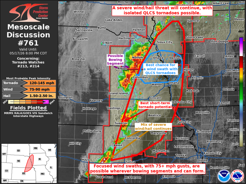
Mesoscale Discussion 0761 NWS Storm Prediction Center Norman OK 0653 PM CDT Sun May 17 2026 Areas affected...portions of eastern Nebraska into northern Kansas and western Iowa Concerning...Tornado Watch 213...214... Valid 172353Z - 180100Z The severe weather threat for Tornado Watch 213, 214 continues. SUMMARY...Severe wind and hail remain a concern with ongoing storms over eastern NE into western IA and northern KS. Focused corridors of severe wind, with isolated QLCS tornadoes, may accompany mature bowing segments. DISCUSSION...The cold front continues to surge southward and merge with the dryline, which may be at least partially contributing to the rapid upscale growth of ongoing multicells and supercells into line segments. Should this trend continue, then severe wind will become the main threat in a couple of hours, with a secondary risk of hail and isolated QLCS tornadoes. Bowing segments may be capable of producing focused corridors of 50+ kt gusts, with some exceeding 65 kts in magnitude. QLCS tornadoes are also most likely with the bowing segments. Supercell tornado potential seems more conditional given the prominent mixed/linear storm modes. One storm in Thayer County, NE is attempting to maintain supercell structure and currently contains a tornado. Given strong instability and vertical wind shear in place, any discrete supercell that can sustain itself will have a conditional potential to produce a strong tornado. ..Squitieri.. 05/17/2026 ...Please see www.spc.noaa.gov for graphic product... ATTN...WFO...DMX...EAX...FSD...OAX...TOP...ICT...GID... LAT...LON 38949816 40139774 41859705 42779635 43189574 43189548 42919527 42429522 41789528 40939539 40169576 39589622 39119718 38949816 MOST PROBABLE PEAK TORNADO INTENSITY...120-145 MPH MOST PROBABLE PEAK WIND GUST...75-90 MPH MOST PROBABLE PEAK HAIL SIZE...1.50-2.50 IN |
|
|
Top/All Mesoscale Discussions/Forecast Products/Home |
|
Source link