| Mesoscale Discussion 753 | |
| < Previous MD | |

|
|
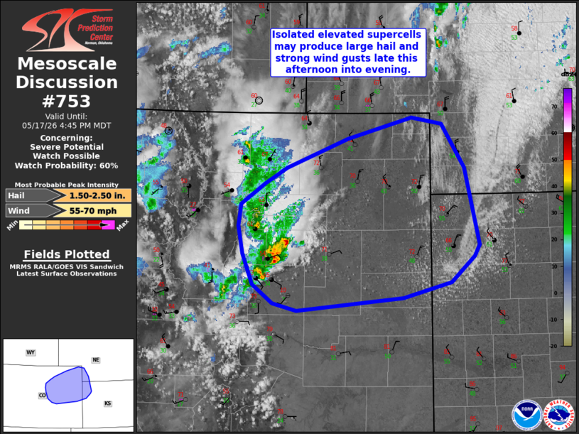
   Mesoscale Discussion 0753
   NWS Storm Prediction Center Norman OK
   0308 PM CDT Sun May 17 2026

   Areas affected...northeast Colorado vicinity

   Concerning...Severe potential...Watch possible

   Valid 172008Z - 172245Z

   Probability of Watch Issuance...60 percent

   SUMMARY...Isolated high-based thunderstorms may pose a risk for
   strong wind gusts and large hail through this evening. A severe
   thunderstorm watch may be needed sometime late this afternoon, but
   timing is uncertain.

   DISCUSSION...Isolated thunderstorms have developed near the
   foothills in the I-25 corridor in central CO. This activity may
   continue to develop and shift east/northeast over the next few
   hours. The downstream airmass is relatively cool and dry in the wake
   of a prior cold frontal passage. However, steep midlevel lapse rates
   and strong vertical shear are present. RAP forecast soundings
   indicate elongated/straight hodographs amid steep low and midlevel
   lapse rates. This may be sufficient for isolated severe storms
   capable of strong downburst winds and large hail. Trends will be
   monitored for possible severe thunderstorm watch issuance later this
   afternoon.

   ..Leitman/Mosier.. 05/17/2026

   ...Please see www.spc.noaa.gov for graphic product...

   ATTN...WFO...LBF...GLD...PUB...BOU...

   LAT...LON   40680337 40950235 40870187 40330150 39370127 39240135
               38920172 38730249 38570418 38660456 38890488 39260504
               39610511 39880506 40140468 40330434 40680337

   MOST PROBABLE PEAK WIND GUST...55-70 MPH
   MOST PROBABLE PEAK HAIL SIZE...1.50-2.50 IN
|
|
|
Top/All Mesoscale Discussions/Forecast Products/Home |
|
Source link