| Mesoscale Discussion 74 | |
| < Previous MD | |

|
|
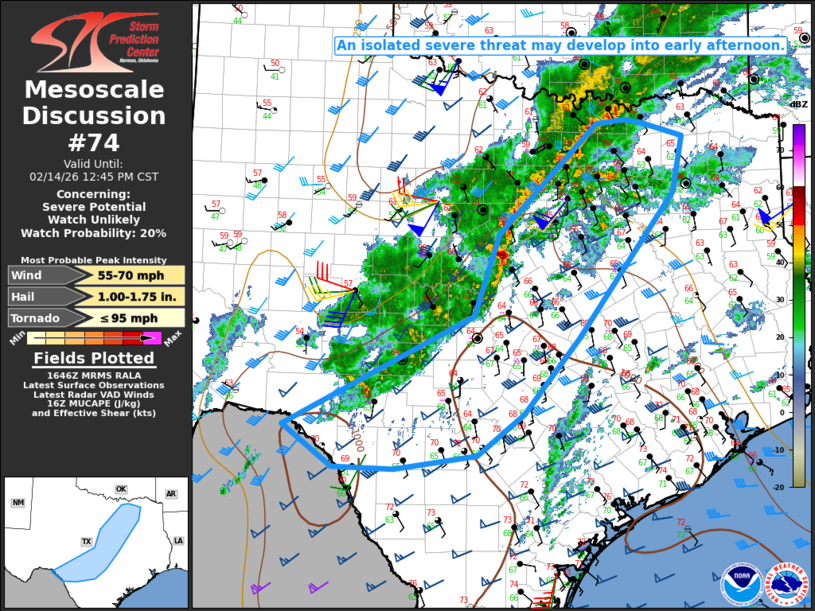
   Mesoscale Discussion 0074
   NWS Storm Prediction Center Norman OK
   1049 AM CST Sat Feb 14 2026

   Areas affected...Parts of south-central into north TX

   Concerning...Severe potential...Watch unlikely

   Valid 141649Z - 141845Z

   Probability of Watch Issuance...20 percent

   SUMMARY...An isolated severe threat may develop into the early
   afternoon. Short-term watch issuance is considered unlikely.

   DISCUSSION...A band of thunderstorms is ongoing this morning from
   south-central into north TX, in advance of a vigorous
   mid/upper-level shortwave trough approaching the southern High
   Plains. Outflow associated with this band of storms has shown some
   acceleration this morning, which will result in eastward progression
   of the ongoing storms through early afternoon. Despite the presence
   of strong deep-layer shear, convection has remained relatively
   disorganized thus far, due to rather weak buoyancy and the
   undercutting influence of the outflow.

   With time, increasing ascent associated with the approaching
   shortwave trough and gradually improving buoyancy (with MLCAPE
   gradually increasing through the 500-1000 J/kg range) may allow for
   some strengthening and increased organization into early afternoon.
   Isolated supercells and/or bowing segments could evolve with time,
   posing at least a localized threat for severe hail and wind. The
   undercutting outflow may continue to limit the magnitude and
   coverage in the short term, and watch issuance is considered
   unlikely through early afternoon.

   An increase in the severe threat is still expected later in the
   afternoon, as storms begin to approach east TX. Parts of
   south-central TX (near the southern periphery of ongoing convection)
   will continue to be monitored for isolated supercell development
   within a somewhat more unstable environment.

   ..Dean/Gleason.. 02/14/2026

   ...Please see www.spc.noaa.gov for graphic product...

   ATTN...WFO...SHV...FWD...EWX...SJT...

   LAT...LON   29630151 31069870 32109833 33539685 33589641 33539615
               33369555 32649570 30779714 29809795 29269864 29099986
               29100077 29630151

   MOST PROBABLE PEAK TORNADO INTENSITY...UP TO 95 MPH
   MOST PROBABLE PEAK WIND GUST...55-70 MPH
   MOST PROBABLE PEAK HAIL SIZE...1.00-1.75 IN
|
|
|
Top/All Mesoscale Discussions/Forecast Products/Home |
|
Source link