| Mesoscale Discussion 734 | |
| < Previous MD | |

|
|
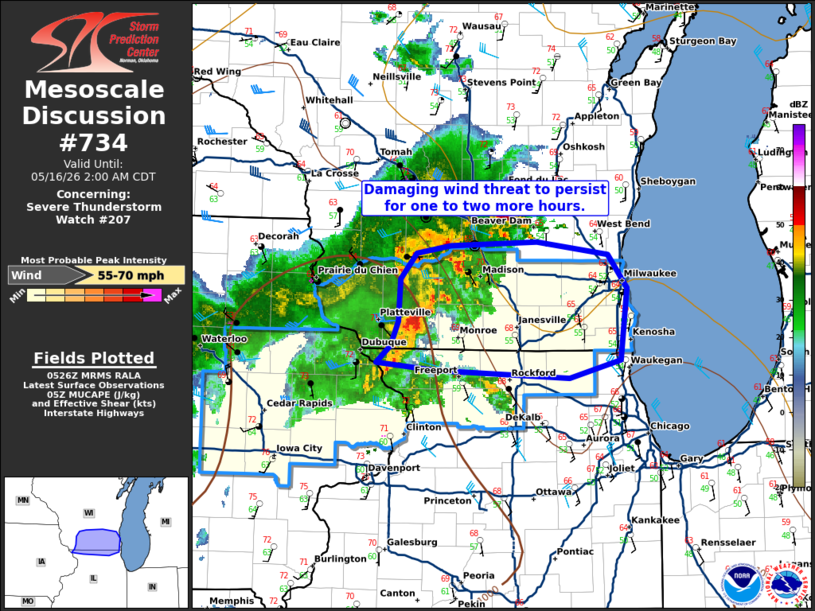
Mesoscale Discussion 0734 NWS Storm Prediction Center Norman OK 1229 AM CDT Sat May 16 2026 Areas affected...southern Wisconsin and far northern Illinois Concerning...Severe Thunderstorm Watch 207... Valid 160529Z - 160700Z The severe weather threat for Severe Thunderstorm Watch 207 continues. SUMMARY...A damaging wind threat will persist for one to 2 more hours across southern Wisconsin and far northern Illinois. DISCUSSION...A small bowing segment persists across southern Wisconsin where a recent 61 mph measured wind gust was recorded by a trained spotter and a 72 mph wind gust was measured by a home weather station. This bow will move into a increasingly stable airmass as it continues east where low to mid 50s dewpoints are present. Despite the weakening instability, some damaging wind threat could persist to the Lake Michigan shore given the 50 knot southwesterly low-level jet on the MKX VWP. Despite strong low-level directional and speed shear, expect the tornado threat to remain low given the 250-350 J/kg MLCIN (per SPC mesoanalysis and HRRR forecast soundings ahead of the bow). ..Bentley.. 05/16/2026 ...Please see www.spc.noaa.gov for graphic product... ATTN...WFO...LOT...MKX...DVN... LAT...LON 42399049 42529033 42729026 43049023 43259006 43308970 43348879 43238805 42988784 42428791 42278845 42348985 42399049 MOST PROBABLE PEAK WIND GUST...55-70 MPH |
|
|
Top/All Mesoscale Discussions/Forecast Products/Home |
|
Source link