| Mesoscale Discussion 732 | |
| < Previous MD | |
|
|
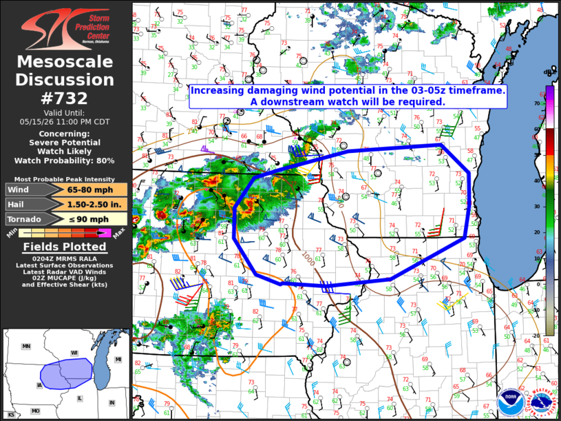
   Mesoscale Discussion 0732
   NWS Storm Prediction Center Norman OK
   0907 PM CDT Fri May 15 2026

   Areas affected...northeast Iowa into southern Wisconsin and far
   northern Illinois

   Concerning...Severe potential...Watch likely

   Valid 160207Z - 160400Z

   Probability of Watch Issuance...80 percent

   SUMMARY...Damaging wind potential is expected to increase in the
   03-05z timeframe from west-to-east across the discussion area. An
   additional downstream watch will likely be required prior to 03:00
   UTC (10 PM CDT).

   DISCUSSION...A couple supercell clusters are ongoing as of 02:00 UTC
   (9 PM CDT) from north of Fort Dodge to near Charles City in northern
   IA, with a general eastward motion of 20-25 kt. Latest
   convection-allowing model guidance suggests that the ongoing storms
   will grow upscale into a bowing MCS over the next 1-3 hours as
   moist, unstable inflow is enhanced by a nocturnally strengthening
   low-level jet. The current east-northeast to west-southwest
   orientation of the broader convective band is currently aligned
   largely parallel to the deep-layer shear vector. The previously
   mentioned model data suggest the bowing complex will assume more of
   a north to south orientation, which would favor the evolution of a
   rear-inflow jet and organized cold pool. That scenario would support
   the potential for a corridor of scattered, strong to severe wind
   gusts from northeast IA into southern WI and potentially far
   northern IL. The wind potential may tend to be more sporadic with
   eastward extent as the convective system moves into a progressively
   more stable environment.

   ..Mead/Smith.. 05/16/2026

   ...Please see www.spc.noaa.gov for graphic product...

   ATTN...WFO...GRB...LOT...MKX...DVN...ARX...DMX...

   LAT...LON   42479308 42959308 43439267 43589211 43879063 43978859
               43508798 42998800 42488811 41848972 41739109 41779203
               41759207 41909259 42479308

   MOST PROBABLE PEAK TORNADO INTENSITY...UP TO 90 MPH
   MOST PROBABLE PEAK WIND GUST...65-80 MPH
   MOST PROBABLE PEAK HAIL SIZE...1.50-2.50 IN
|
|
|
Top/All Mesoscale Discussions/Forecast Products/Home |
|
Source link