| Mesoscale Discussion 727 | |
| < Previous MD Next MD > | |

|
|
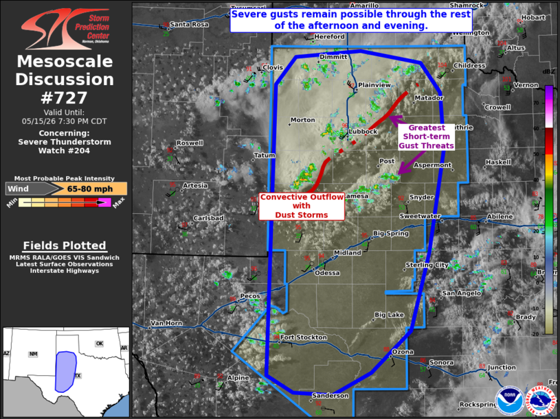
Mesoscale Discussion 0727 NWS Storm Prediction Center Norman OK 0601 PM CDT Fri May 15 2026 Areas affected...portions of western Texas Concerning...Severe Thunderstorm Watch 204... Valid 152301Z - 160030Z The severe weather threat for Severe Thunderstorm Watch 204 continues. SUMMARY...Severe gusts will remain a concern through the afternoon and evening hours. DISCUSSION...Clusters of high-based thunderstorms, with a history of isolated measured severe (50+ kt) convective gusts, continues to progress eastward across western TX, amid a deeply mixed, unstable boundary layer. Congealing outflows have been noted via KLBB reflectivity data across the TX Panhandle, where blowing dust with zero visibility have also been reported. Scattered high-based cells will continue to develop along this outflow, and with more robust CU closer to the TX Rolling Plains over the next couple of hours. As long as the deep and mixed boundary layer remains in place, any of the stronger storm cores in this environment may support erratic strong to severe gusts. ..Squitieri.. 05/15/2026 ...Please see www.spc.noaa.gov for graphic product... ATTN...WFO...SJT...LUB...MAF... LAT...LON 30460305 34240296 34600265 34690163 34530070 34140039 33410034 32050060 31040089 30490149 30200206 30230265 30460305 MOST PROBABLE PEAK WIND GUST...65-80 MPH |
|
|
Top/All Mesoscale Discussions/Forecast Products/Home |
|
Source link