|
|
| Mesoscale Discussion 705 | |
| < Previous MD Next MD > | |

|
|
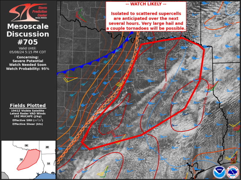
   Mesoscale Discussion 0705
   NWS Storm Prediction Center Norman OK
   0246 PM CDT Wed May 08 2024

   Areas affected...parts of northern into central Texas

   Concerning...Severe potential...Watch needed soon

   Valid 081946Z - 082215Z

   Probability of Watch Issuance...95 percent

   SUMMARY...Isolated to perhaps scattered severe storms capable of
   very large hail and a tornado or two are expected over the next
   several hours from parts of central into northeast Texas.

   DISCUSSION...Deeper convection is beginning to form along the
   dryline near San Saba and Mills Counties, with increasing Cu depth
   extending northeastward along the dryline. A very moist and
   extremely unstable air mass resides east of the dryline, with MLCAPE
   in excess of 4000 J/kg. Effective deep-layer shear up to 50 kt with
   a large cross component to the boundary will favor supercell storm
   mode, with very large hail expected. A few tornadoes may occur as
   well, perhaps brief but locally intense, given extreme instability
   and sufficient low-level shear. An expansive, uncapped warm sector
   suggests cells may remain severe for a long duration.

   ..Jewell/Smith.. 05/08/2024

   ...Please see www.spc.noaa.gov for graphic product...

   ATTN...WFO...SHV...HGX...FWD...OUN...EWX...SJT...

   LAT...LON   31569513 30709679 30209871 30439902 31019868 31289838
               31949771 32819719 33669681 33799589 33869520 33629455
               33469435 32449456 31569513
|
|
|
Top/All Mesoscale Discussions/Forecast Products/Home |
|