| Mesoscale Discussion 7 | |
| < Previous MD | |
|
|
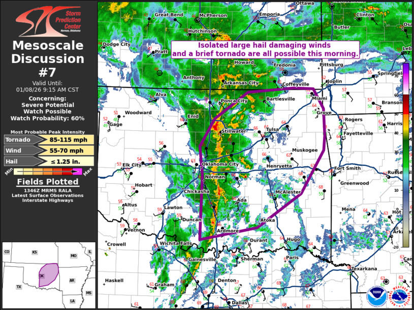
   Mesoscale Discussion 0007
   NWS Storm Prediction Center Norman OK
   0749 AM CST Thu Jan 08 2026

   Areas affected...central and eastern Oklahoma

   Concerning...Severe potential...Watch possible

   Valid 081349Z - 081515Z

   Probability of Watch Issuance...60 percent

   SUMMARY...Isolated large hail and damaging wind and a brief tornado
   are all possible this morning.

   DISCUSSION...A line of storms has become better defined this morning
   along the I-35 corridor. Within this line, occasional areas of
   circulation have been noted and some gusty winds (60 mph at the
   Yukon, OK mesonet site). Each of these circulations has been very
   short lived, likely due to the limited instability. One TDS has been
   observed near Purcell this morning. One or two additional brief
   tornadoes may be possible within this line as it moves northeast
   with favorable low-level shear present on the INX VWP.

   A brief window for severe weather potential will exist for the next
   1 to 2 hours along the I-44 corridor from I-35 to northeast
   Oklahoma.

   This line is moving quickly east and will eventually outrun the best
   low-level moisture which should bring an end to the greater short
   term threat.

   ..Bentley/Mosier.. 01/08/2026

   ...Please see www.spc.noaa.gov for graphic product...

   ATTN...WFO...SGF...TSA...ICT...OUN...

   LAT...LON   34079754 35329750 35899756 36429721 36949642 37039530
               37009483 36619459 36109457 35809461 34979516 34309619
               34079754

   MOST PROBABLE PEAK TORNADO INTENSITY...85-115 MPH
   MOST PROBABLE PEAK WIND GUST...55-70 MPH
   MOST PROBABLE PEAK HAIL SIZE...UP TO 1.25 IN
|
|
|
Top/All Mesoscale Discussions/Forecast Products/Home |
|
Source link