|
|
| Mesoscale Discussion 699 | |
| < Previous MD Next MD > | |

|
|
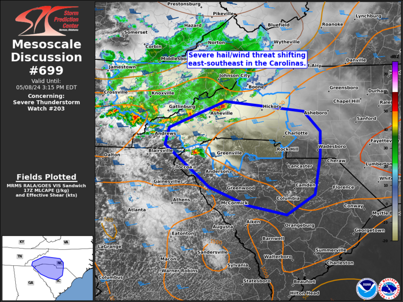
Mesoscale Discussion 0699 NWS Storm Prediction Center Norman OK 1248 PM CDT Wed May 08 2024 Areas affected...western to central Carolinas Concerning...Severe Thunderstorm Watch 203... Valid 081748Z - 081915Z The severe weather threat for Severe Thunderstorm Watch 203 continues. SUMMARY...A mix of discrete cells and clusters should spread east-southeast across parts of the western Carolinas through late afternoon. Expansion of WW 203 and/or an additional severe thunderstorm watch appears likely. DISCUSSION...Convective evolution of multiple supercells and clusters has been decidedly southeastward over the past couple hours along large-scale outflow. This has diminished the overall severe threat in northeast TN. Meanwhile, a couple supercells embedded with the cluster persist near the Asheville, NC area, while a separate discrete supercell was located farther south to the west of Greenville, SC. Surface temperatures across the lower Piedmont area have warmed through the mid to upper 80s, which will likely support a continued severe hail and damaging wind threat downstream. The 16Z HRRR appears to be an outlier with its indication of convection diminishing as it spreads east of the higher terrain. While low-level flow is weak per GSP VWP data, abundant mid to upper speed shear will favor embedded supercells and clusters persisting, reasonably simulated by the 12Z NSSL-MPAS. ..Grams.. 05/08/2024 ...Please see www.spc.noaa.gov for graphic product... ATTN...WFO...RAH...ILM...CAE...GSP... LAT...LON 35898219 35708037 35318000 34838000 34128014 33758078 33938167 34278253 34738311 35068355 35398346 35398346 35898219 |
|
|
Top/All Mesoscale Discussions/Forecast Products/Home |
|


