
|
|
| Mesoscale Discussion 690 | |
| < Previous MD | |
|
|
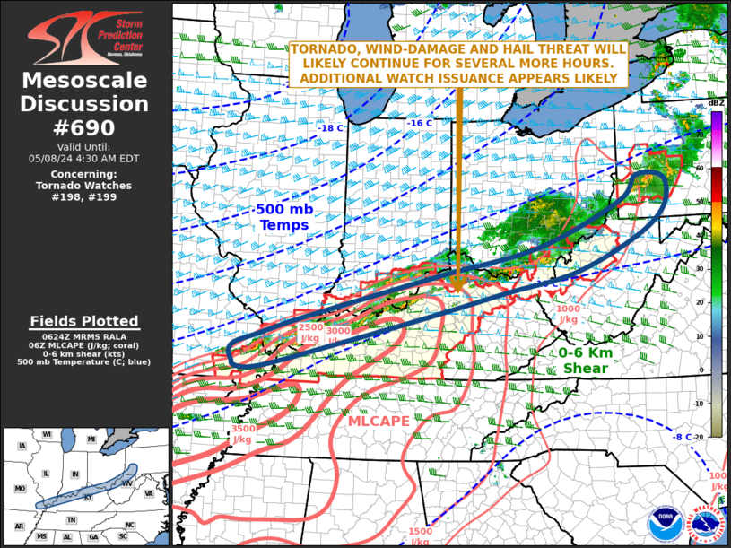
Mesoscale Discussion 0690 NWS Storm Prediction Center Norman OK 0126 AM CDT Wed May 08 2024 Areas affected...Ohio Valley Concerning...Tornado Watch 198...199... Valid 080626Z - 080830Z The severe weather threat for Tornado Watch 198, 199 continues. SUMMARY...A tornado, wind-damage and hail threat will likely continue for several more hours across the Ohio Valley. Additional weather watch issuance appears likely. DISCUSSION...The latest mosaic radar imagery shows a multi-segmented line of strong to severe storms located near the Ohio River from southeast Missouri east-northeastward into southwestern Pennsylvania. The RAP shows the strongest instability from southeast Missouri to central Kentucky, where MLCAPE is estimated to be in the 2000 to 3500 J/kg range. Along this corridor, regional WSR-88D VWPs and RAP forecast soundings have 0-6 km in the 45 to 55 knot range, suggesting the supercells and bowing line segments will be possible tonight. 0-3 km storm-relative helicities near 300 m2/s2 suggests that an isolated tornado threat may accompany the strongest of supercells. However, the greater threat should be for wind damage associated with the more intense line segments. The threats are expected to persist through much of the night, but should become somewhat more isolated with time. ..Broyles.. 05/08/2024 ...Please see www.spc.noaa.gov for graphic product... ATTN...WFO...CTP...PBZ...RLX...JKL...ILN...LMK...PAH... LAT...LON 39947934 39368008 38688167 38318339 37818543 37268759 36788949 36759012 36859022 37049029 37229015 37398961 37808837 38648507 39208255 40088047 40578002 40517933 39947934 |
|
|
Top/All Mesoscale Discussions/Forecast Products/Home |
|