|
|
| Mesoscale Discussion 689 | |
| < Previous MD | |

|
|
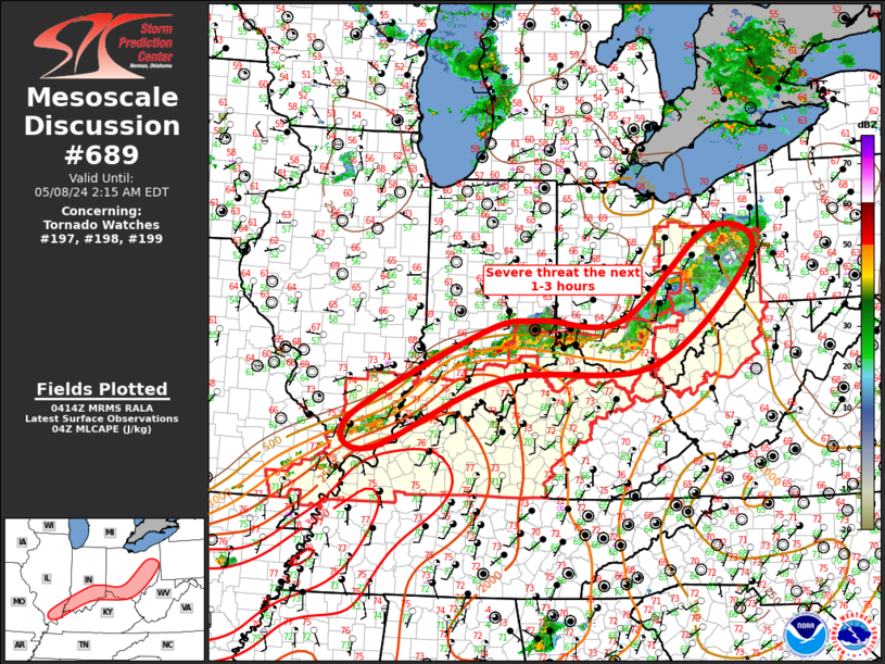
Mesoscale Discussion 0689 NWS Storm Prediction Center Norman OK 1116 PM CDT Tue May 07 2024 Areas affected...Ohio Valley Concerning...Tornado Watch 197...198...199... Valid 080416Z - 080615Z The severe weather threat for Tornado Watch 197, 198, 199 continues. SUMMARY...Scattered severe thunderstorms will sag southeast across the Ohio Valley into the early morning hours. DISCUSSION...Great Lakes short-wave trough is shifting east late this evening and the primary corridor of large-scale ascent is focused across the lower Great Lakes/upper OH Valley. Deep southwesterly flow will persist in the wake of this feature, and water-vapor imagery does not depict any appreciable upstream disturbances. Northern corridor of stronger instability extends into this region, and ongoing scattered severe convection should continue to sag southeast toward the OH River Valley over the next several hours. Large hail threat appears to have waned a bit but several supercells persist along this corridor. Given the observed shear, some tornado risk continues, along with hail approaching 1-1.5 inches. ..Darrow.. 05/08/2024 ...Please see www.spc.noaa.gov for graphic product... ATTN...WFO...PBZ...RLX...CLE...ILN...LMK...IND...PAH...ILX... LAT...LON 39488517 39478344 40958158 40548068 38768274 38538590 37368859 37878905 39298631 39488517 |
|
|
Top/All Mesoscale Discussions/Forecast Products/Home |
|