|
|
| Mesoscale Discussion 682 | |
| < Previous MD | |

|
|
   Mesoscale Discussion 0682
   NWS Storm Prediction Center Norman OK
   0524 PM CDT Tue May 07 2024

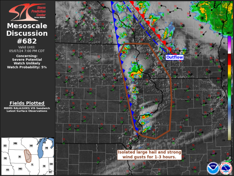
   Areas affected...Portions of upper Mississippi Valley

   Concerning...Severe potential...Watch unlikely

   Valid 072224Z - 080000Z

   Probability of Watch Issuance...5 percent

   SUMMARY...Isolated marginally severe hail and strong wind gusts are
   possible with storms in eastern Iowa, southwestern Wisconsin, and
   northwest Illinois.

   DISCUSSION...A very narrow warm sector has developed in the upper
   Mississippi Valley southeast of an occluded surface cyclone.
   Deep-layer shear is quite marginal, but a few semi-organized storms
   are possible over the next 1-3 hours. The threat should be short
   lived as the storms will likely move into outflow from storms along
   the warm front (particularly in Wisconsin). Furthermore, dewpoints
   have been mixing out over the last hour. Isolated marginally severe
   hail and strong wind gusts will be possible with this activity.

   ..Wendt/Hart.. 05/07/2024

   ...Please see www.spc.noaa.gov for graphic product...

   ATTN...WFO...ILX...MKX...DVN...ARX...

   LAT...LON   43199188 43539166 43529071 42538984 41888980 40998989
               40749042 40829095 41029125 43199188
|
|
|
Top/All Mesoscale Discussions/Forecast Products/Home |
|


