|
|
| Mesoscale Discussion 680 | |
| < Previous MD | |

|
|
   Mesoscale Discussion 0680
   NWS Storm Prediction Center Norman OK
   0333 PM CDT Tue May 07 2024

   Areas affected...southern Lower MI...eastern IN...western OH...far
   northern KY

   Concerning...Severe potential...Tornado Watch likely

   Valid 072033Z - 072200Z

   Probability of Watch Issuance...80 percent

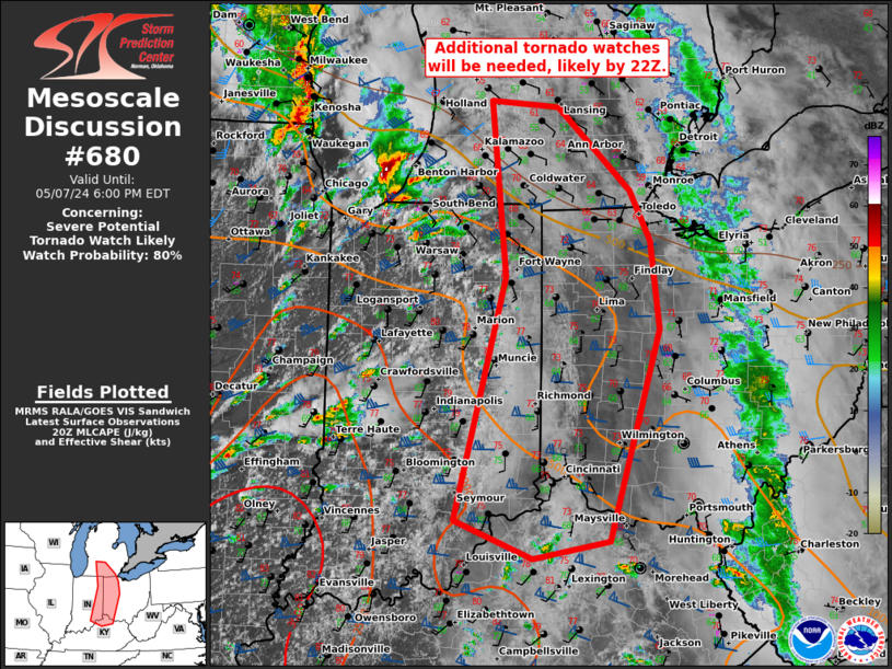
   SUMMARY...As supercells spread quickly east-northeast from southern
   Lower MI and northwest IN, an additional tornado watch/watches will
   be needed prior to 22Z. This may also include a combined/separate
   watch farther south in eastern IN/western OH ahead of supercells
   intensifying over the Wabash Valley.

   DISCUSSION...As mentioned in MCD 0679, an increasingly favorable
   setup for supercells, a couple of which may be long-tracked, is
   underway across northwest IN to the Wabash Valley. The northern
   storms may being to outpace the rapid boundary-layer
   warming/moistening that is occurring across northeast IN and
   northwest OH into southern Lower MI. Nevertheless, the intense
   mid-level jet will likely foster sustained supercells even as they
   become slightly elevated towards southeast Lower MI. With backed
   low-level flow and ample low-level shear (per IWX VWP data), the
   tornado threat will remain prominent with any supercells along and
   south of the surface warm front. A couple strong tornadoes are
   possible.

   ..Grams/Smith.. 05/07/2024

   ...Please see www.spc.noaa.gov for graphic product...

   ATTN...WFO...CLE...JKL...ILN...DTX...LMK...IWX...GRR...IND...

   LAT...LON   42758544 42698458 41898367 41398340 40538329 38478394
               38308491 38688589 41048526 42758544
|
|
|
Top/All Mesoscale Discussions/Forecast Products/Home |
|


