|
|
| Mesoscale Discussion 670 | |
| < Previous MD | |

|
|
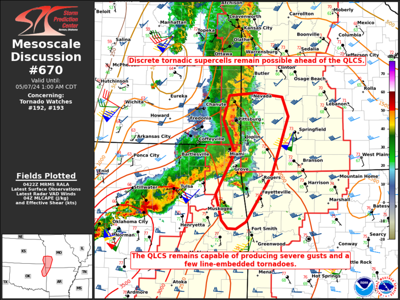
Mesoscale Discussion 0670 NWS Storm Prediction Center Norman OK 1125 PM CDT Mon May 06 2024 Areas affected...Eastern OK into extreme southeast KS...southwest MO...far northwest AR Concerning...Tornado Watch 192...193... Valid 070425Z - 070600Z The severe weather threat for Tornado Watch 192, 193 continues. SUMMARY...Tornadic supercells remain possible ahead of an expanding QLCS. The QLCS will remain capable of producing severe gusts and perhaps a few line-embedded tornadoes. DISCUSSION...Renewed storm development has been noted over the last hour across eastern OK, to the east and south of an expanding QLCS approaching southwest MO. Regional VWPs continue to depict a very favorable wind profile for tornadic supercells, within a moderate to strongly unstable environment. Any discrete supercells that can become established ahead of the line will pose a strong tornado threat into the early overnight hours. Otherwise, the QLCS will continue to move eastward into southwest MO with a threat for severe gusts. Line-embedded tornadoes also remain possible with the QLCS, especially where it overtakes any discrete cells that develop in advance of the line. ..Dean.. 05/07/2024 ...Please see www.spc.noaa.gov for graphic product... ATTN...WFO...SGF...TSA... LAT...LON 35869512 36079519 36849476 37459501 37919488 37959426 37889366 37519351 36449389 35579449 35439473 35459491 35599506 35869512 |
|
|
Top/All Mesoscale Discussions/Forecast Products/Home |
|