|
|
| Mesoscale Discussion 664 | |
| < Previous MD Next MD > | |

|
|
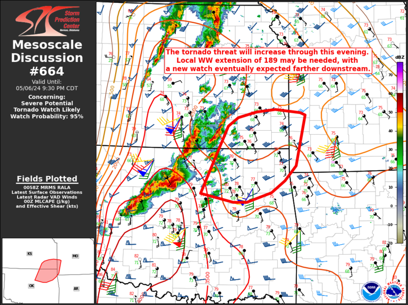
Mesoscale Discussion 0664 NWS Storm Prediction Center Norman OK 0800 PM CDT Mon May 06 2024 Areas affected...Northeast OK into southeast KS and extreme southwest MO Concerning...Severe potential...Tornado Watch likely Valid 070100Z - 070230Z Probability of Watch Issuance...95 percent SUMMARY...The tornado threat will increase through the evening. Local extension of WW 189 may be needed, with Tornado Watch issuance eventually expected downstream. DISCUSSION...Convective showers are beginning to increase from central/northeast OK into southeast KS, ahead of the primary corridor of supercells to the southwest. With a continued increase of the low-level jet expected into the evening, there will be some potential for these showers to deepen into mature supercells with time, within a very favorable environment characterized by MLCAPE in excess of 2000 J/kg and strong low-level and deep-layer shear. Should this occur, some increase in tornado potential will be possible through mid evening, with an increase in storm coverage later tonight as ongoing supercells across OK and far southern KS spread east-northeastward. Local extension of WW 189 may be needed across parts of northeast OK/southeast KS in the short term. New Tornado Watch issuance will eventually be needed farther northeast, extending into southwest MO. Timing of the new watch will be dependent on the evolution of developing cells ahead of the main cluster of convection to the west. ..Dean/Guyer.. 05/07/2024 ...Please see www.spc.noaa.gov for graphic product... ATTN...WFO...SGF...TSA...ICT...OUN... LAT...LON 36059690 37479619 37659594 37769545 37819496 37759432 37709419 36649443 36329472 36089507 35889571 35879606 36059690 |
|
|
Top/All Mesoscale Discussions/Forecast Products/Home |
|


