|
|
| Mesoscale Discussion 663 | |
| < Previous MD Next MD > | |

|
|
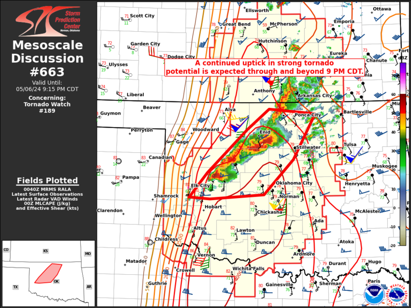
Mesoscale Discussion 0663 NWS Storm Prediction Center Norman OK 0743 PM CDT Mon May 06 2024 Areas affected...Northwest into central OK Concerning...Tornado Watch 189... Valid 070043Z - 070215Z The severe weather threat for Tornado Watch 189 continues. SUMMARY...An uptick in strong tornado potential is expected through and beyond 9 PM CDT. DISCUSSION...A southwest to northeast corridor of supercells has become established from west-central into north-central OK. Midlevel mesocyclones with the cells across Blaine and Kingfisher County have intensified this evening as they have moved into an environment characterized by increasing low-level moisture (with dewpoints near 70 F), strong to extreme instability, and strengthening low-level flow/shear as noted on the KTLX and KVNX VWPs. The cell over Garfield County earlier produced a tornado, and tornado potential with the other storms along this corridor will increase as they move eastward this evening. The 00Z OUN sounding depicts a volatile environment, with MLCAPE in excess of 3500 J/kg, effective shear of around 60 kt, and 0-1 km SRH in excess of 300 m2/s2. Low-level flow/shear will continue to increase through the evening, becoming even more favorable for strong to intense tornadoes. The primary uncertainty this evening is the cluster storm mode that has developed, but the ongoing cell south of Enid and the trailing cell over Custer County will both have an opportunity to move through a very favorable environment through 9 PM CDT. ..Dean.. 05/07/2024 ...Please see www.spc.noaa.gov for graphic product... ATTN...WFO...TSA...OUN... LAT...LON 35279944 35729903 36509814 36889766 36799661 35969711 35319777 35239898 35279944 |
|
|
Top/All Mesoscale Discussions/Forecast Products/Home |
|