|
|
| Mesoscale Discussion 662 | |
| < Previous MD Next MD > | |

|
|
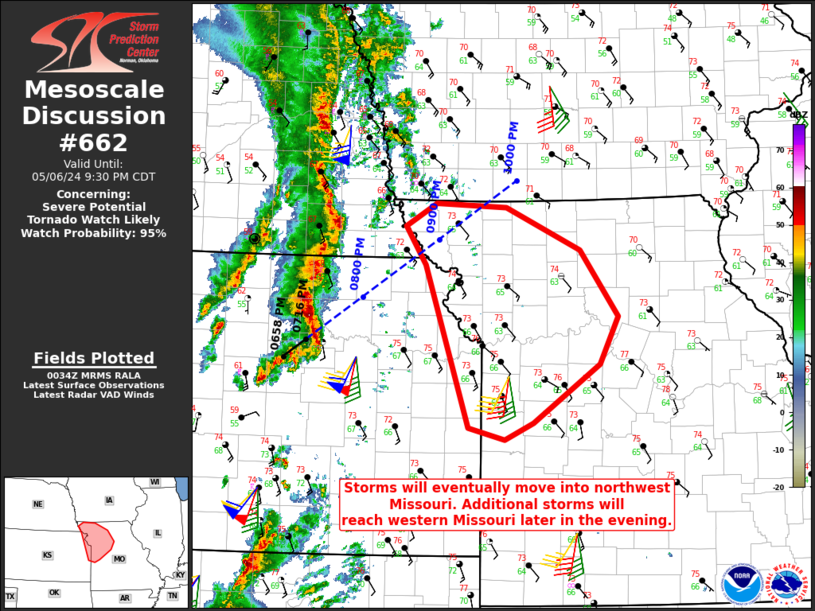
   Mesoscale Discussion 0662
   NWS Storm Prediction Center Norman OK
   0736 PM CDT Mon May 06 2024

   Areas affected...Northwest and west-central Missouri

   Concerning...Severe potential...Tornado Watch likely

   Valid 070036Z - 070230Z

   Probability of Watch Issuance...95 percent

   SUMMARY...A tornado watch will likely be needed this evening as
   storms move into western portions of Missouri. QLCS tornadoes and
   damaging winds are the expected primary hazards.

   DISCUSSION...A linear segment east of Concordia, KS will continue
   northeast this evening. This activity may reach northwest Missouri
   between 8:30-9 PM CDT based on current projections. As upper-level
   forcing continues to push eastward into the overnight, the
   expectation is for additional storms to form along the composite
   dryline/Pacific front later this evening. Those storms would likely
   impact portions of western Missouri. Low-level hodographs on the
   KEAX VAD already show sufficient shear for rotating storms. This
   shear is expected to increase as the low-level jet strengthens and
   shifts eastward -- KTWX to the west already is showing 50 kts
   between 1-2 km. While the overall tornado risk will be somewhat
   mitigated by a linear storm mode, QLCS tornadoes will still be
   possible as will damaging wind gusts. A tornado watch will likely be
   issued in the next 1-2 hours.

   ..Wendt/Guyer.. 05/07/2024

   ...Please see www.spc.noaa.gov for graphic product...

   ATTN...WFO...EAX...OAX...TOP...

   LAT...LON   39929534 40329559 40549519 40519428 40079333 39419283
               38929307 38339393 38179431 38299478 39929534
|
|
|
Top/All Mesoscale Discussions/Forecast Products/Home |
|