|
|
| Mesoscale Discussion 659 | |
| < Previous MD Next MD > | |

|
|
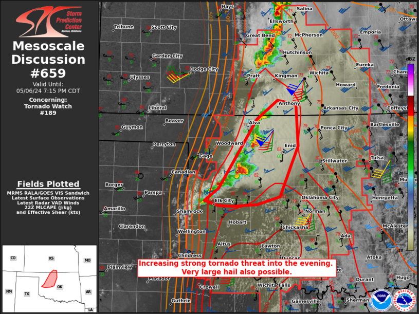
Mesoscale Discussion 0659 NWS Storm Prediction Center Norman OK 0542 PM CDT Mon May 06 2024 Areas affected...West-central into northwest/north-central OK...extreme south-central KS Concerning...Tornado Watch 189... Valid 062242Z - 070015Z The severe weather threat for Tornado Watch 189 continues. SUMMARY...The threat for strong and potentially long-tracked tornadoes is expected to increase into this evening. Very large hail will also be possible with any supercell. DISCUSSION...Three mature supercells are ongoing across northwest OK as of 5:30 PM CDT. Initial development occurred in an environment characterized by warm temperatures (well into the 80s F) and dewpoints generally in the mid 60s F. However, dewpoints downstream of the ongoing cells into north-central OK are in the upper 60s to near 70F, supporting even greater buoyancy (MLCAPE of 3000-4000 J/kg) and a more favorable thermodynamic environment for tornadoes. In addition, VWP data from KOUN and KVNX depict a notable increase in low-level flow over the last hour, with some modest backing of surface winds noted in recent Oklahoma Mesonet data. 0-1 km SRH of around 200 m2/s2 was noted in the 21Z OUN sounding, with values expected to increase above 300 m2/s2 into this evening. The combination of strengthening low-level shear and strong to extreme instability will support a rapid increase in potential for strong and possibly long-tracked tornadoes as storms spread east-northeastward this evening. In addition to the tornado threat, very large hail and localized severe gusts will also remain possible. Additional development southwest of the ongoing supercells remains possible with time this evening, as the low-level jet continues to increase. ..Dean.. 05/06/2024 ...Please see www.spc.noaa.gov for graphic product... ATTN...WFO...ICT...OUN...DDC... LAT...LON 35699931 36929848 37279802 37189762 36459758 36129773 35549798 35419847 35379900 35389932 35479963 35699931 |
|
|
Top/All Mesoscale Discussions/Forecast Products/Home |
|


