|
|
| Mesoscale Discussion 658 | |
| < Previous MD | |

|
|
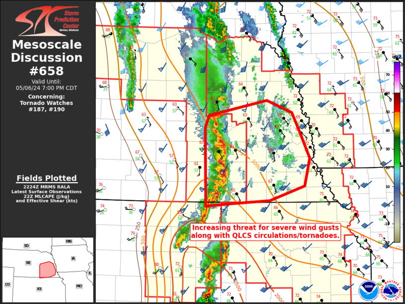
Mesoscale Discussion 0658 NWS Storm Prediction Center Norman OK 0527 PM CDT Mon May 06 2024 Areas affected...Southeastern Nebraska Concerning...Tornado Watch 187...190... Valid 062227Z - 070000Z The severe weather threat for Tornado Watch 187, 190 continues. SUMMARY...A line segment in southeast Nebraska will continue to move into a destabilizing environment this evening with aid from mid-level ascent. Severe winds and QLCS circulations/tornadoes will be possible. DISCUSSION...A more organized line of storms has developed in south-central Nebraska. Though buoyancy has been limited by cloud cover, regional surface observations show dewpoints reaching the low 60s F ahead of this line. This moisture advection should continue this evening. Objective mesoanalysis shows 1000 J/kg MLCAPE in far southeast Nebraska currently. This line of storms will be capable of severe wind gusts and is expected to persist as continued mid-level ascent pushes into central/eastern Nebraska this evening. QLCS circulations/tornadoes are also possible. KUEX has showed occasional low-level velocity couplets over the last hour. The northward extent of the threat is a bit uncertain as destabilization becomes less likely farther north. ..Wendt.. 05/06/2024 ...Please see www.spc.noaa.gov for graphic product... ATTN...WFO...OAX...TOP...GID... LAT...LON 41299830 41509822 41769689 41559632 41259616 40759593 40289604 40029683 39979781 39929827 41299830 |
|
|
Top/All Mesoscale Discussions/Forecast Products/Home |
|


